
Bridger-Teton National Forest Projects
Kemmerer Ranger District: Kemmerer Roadside Treatments
The purpose of the Kemmerer Ranger District Roadside treatments (KRT) is to support Potential Operational Delineations (PODS) and support fire management.
PODS to pre-plan for fire using a risk management approach, and to give land managers a process for developing landscape-scale wildfire response options before fires start. The KRT would increase the response options to fires within the Kemmerer Ranger District. Fire plays a natural role in the ecosystem and can serve as a land management tool, but without pre-work and planning actions, managers are often left in a defensive suppression stance.
The KRT is located along Forest Service roads 10062, 10069, 10172, 10193, and Highway 89. The legal locations are included within the Kemmerer Ranger District. The project boundaries are located along these roads and currently total 9,224 acres. The treatment units identified within the KRT total 1,029 acres.
Thinning and piling of fuels to occur in units associated with 2H, 2I, and 2J after August 1st of 2025.
For more information on this project contact Tim Sherwin, Fire Management Specialist (Fuels), 307-828-5112.
Kemmerer Ranger District: Hams Fork Vegetation Treatment Project
This multi-unit project area covering approximately 74,267 acres is a result of the Hams Fork decision which includes timber sales, aspen restoration, hazard tree removal and prescribed burning.
The purpose of this project is to improve existing aspen stands by prescribed burning in a large area to stimulate aspen cover types. This objective will allow improvement over a large enough area to help minimize impacts from big game animals. In addition to lowering fuel loads and benefiting wildlife, the project will also enhance the visual quality of aspen.
For more information on this project contact Tim Sherwin, Fire Management Specialist (Fuels), 307-828-5112
Kemmerer Ranger District: La Barge Vegetation Restoration Project
Continued fire suppression has attributed to the homogeneous, older, conifer-dominated landscape. There are currently large areas of the late secessional mountain sagebrush habitat resulting in the reduction of diversity in herbaceous plants. There remains a need to increase the health, vigor and resiliency of forest stands while diversifying the sagebrush successional stages. The La Barge Vegetation Restoration project area is 52,573 acres. 2,217 acres have been identified for future prescribed fire operations to be conducted over multiple years and broken into smaller units.
Thinning and piling of fuels to occur in units 29, 8, 17, 9, and 10 after August 1st of 2025.
For more information on this project contact Tim Sherwin, Fire Management Specialist (Fuels), 307-828-5112
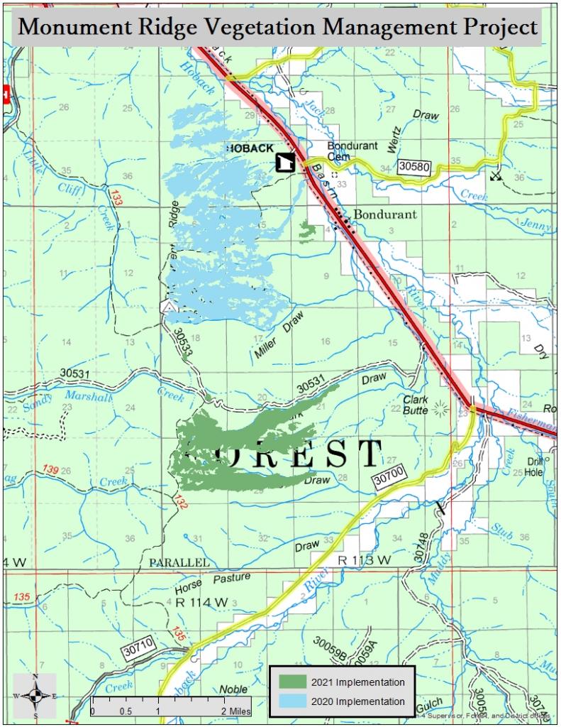
Big Piney Ranger District: Monument Ridge Vegetation and Recreation Management project
The Monument Ridge Vegetation and Recreation Management Project, proposed by the Sublette County Collaborative, is multifaceted. It addresses vegetation management within the wildland urban interface, wildlife habitat enhancement activities, along with safety and access improvements for recreation. These activities are set to improve forest health and promote wildlife populations for elk, mule deer, and sage grouse. This project will provide positive wildlife benefits and recreation opportunities well into the future.
Greys River Ranger District: Greys River Roadside Treatments
The purpose of the Greys River Ranger District Roadside Treatments (GRRT) is to support Potential Operational Delineations (PODS) and support fire management. PODS allow for fire pre-planning using a risk management approach and give land managers a formal process for developing landscape-scale wildfire response options before fires start.
The GRRT is located along Forest Service roads 10081, 10124, 10138, 10072, and Highway 89. The legal locations are included within the Greys River District. The project boundaries are located along these roads and currently total 18,144 acres. The treatment units identified within the GRRT total 2,093 acres.
Prescribed pile burning of the fuels to occur in units associated with 3B in the fall/winter of 2025.
For more information on prescribed fire, fuels reduction projects and defensible space, call the Greys River Ranger District at 307-886-5300.
Greys River Ranger District: Star Valley Front Vegetation Project
The Greys River Ranger District of the Bridger-Teton National Forest plans to implement a 2,000-acre prescribed burn, southern portions of Unit 2B and 2A, in the spring of 2025. Unit 2B and 2A are within Unit 2 of the Star Valley Front Vegetation Treatment Project is located on the Forest Service between Afton and Grover, Wy. Additional units are targeted for implementation this fall. These units include the Unit 9 (Strawberry unit) and unit 8. More information will be shared via a press release when the prescribed burning opportunity becomes available.
The Star Valley Front Vegetation Treatment Project is located east of Star Valley and consists of a 72,577-acre project area with 31,477 acres of proposed burn units extending from Strawberry Creek south to Cottonwood Creek, from the forest boundary to the top of the Salt River Range. The main purpose for treating vegetation in the Star Valley Front Project Area is to begin restoring a balance of age classes in mountain shrubland, mountain big sagebrush, aspen, and conifer communities.
This vegetation treatment is a cooperative effort between the U.S. Forest Service, Wyoming Game & Fish Department, Wyoming Wildlife and Natural Resources Trust, and other partners.
For more information on this project contact Timothy Sherwin, Fire Management Specialist (Fuels), 307-828-5112.
Jackson Ranger District: Teton to Snake Fuels Reduction Projects 2025
Teton to Snake (T-6)
Fuels mitigation contactors will initiate the final phase within the Phillips Ridge treatment area as early as July 15th. Some heavy equipment activity is excepted to impact trails in the area while hazardous trees are fallen and moved to loading areas. The Jackson Ranger District will work with contactors and recreationalists visiting the area to help minimize trail delays and closures by using a "phased approach" while work is under way in the immediate project areas. These short-term closures and delays are necessary for public safety and to help expedite the treatment progress.
Teton to Snake (T-43)
This Red Top unit is a small 8-acre parcel with thin, cut and pile strategy addressing community protection directly adjacent to private property south of Redtop meadows. Local fire staff will prepare piles for burning later and after the vegetation cures, guaranteeing complete consumption during the burning process.
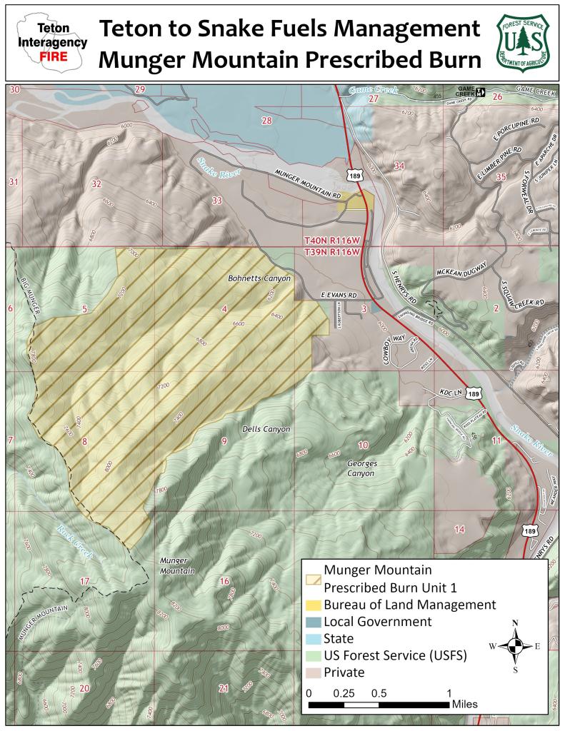
Munger Mountain Prescribed Fire (RX) (PF-47)
Beginning spring of 2025, north zone fuels staff plans to begin implementation of Munger Mountain Prescribed Fire Unit (1,663 acres). This unit involves a multi-phase/multi-year approach, treating smaller segments of the overall unit at a time. Unit field work including ongoing monitoring and protection of values through fuels reduction activities will begin onsite this spring and summer. When conditions are met in 2025, fire personnel will begin burning within the unit as snow recedes, targeting lighter fuels including grass and brush within the unit and heavier fuels along the unit boundary. Completion of this initial stage will allow for safer and more manageable firing operations in future entries that will involve burning timbered areas of the unit that create more active fire behavior.
Upper Gros Ventre Wildlife Enhancement -Prescribed Fire (RX)
Primary objectives include burning to enhance wildlife habitat in the Gros Ventre drainage. Elk, mule deer, pronghorn, and bighorn sheep benefit from open grassland and forb communities and healthy aspen stands. Unnatural fire suppression has greatly altered successional fire regimes in this area, resulting in a decline in aspen community health from advanced succession and conifer encroachment. Habitat enhancement and maintenance on the Bridger-Teton is particularly important to meet the interagency objective of increasing elk utilization of native winter range as an alternative to feed grounds, particularly in the context of increasing risk of wildlife disease transmission. This project is an extension of the Lower Gros Ventre Prescribed Fire Treatments completed in 2010 and is supported by Wyoming Game and Fish Trust Fund.
Map and flyer will be posted soon
Pinedale Ranger District: Big Sandy Fuels Reduction Project
Plan is to treat up to 3,000 ac to improve forest health, protect infrastructure and egress within the Big Sandy wildland-urban interface area and portion of the West Slope Winds roadless area. Actions include thinning, sanitation, salvage and pile burning.
Grand Teton National Park Projects - 2025
Colter Bay Ridgetop
The Colter Bay Ridgetop Unit is in and adjacent to the Coulter Bay developed Area. Several previously completed hazardous fuels reductions units are located within and directly adjacent to the unit. The Coulter Bay Housing Footprint in on the southeastern side of the developed area and encompasses the seasonal and permanent housing in Coulter Bay. This is the 3rd and final year working on this project. The objectives of the project are to reduce the wildland fire fuels loading to help protect values when wildfires threaten the area.
Beaver Creek Historic District
The Beaver Creek Historic District treatment is located on the West side of the Beaver Creek Employee Housing Area. The historic district is an area that contains many historic structures and dwellings dating back to the establishment of Grand Teton National Park. This project will help maintain defensible space in the Wildland Urban Interface (WUI), and reduce hazard trees in the developed area.
Historic Structures Mowing
This annual effort will treat primarily grass and herbaceous fuels in the immediate vicinity of several historic properties in Grand Teton National Park. These mechanical treatments are completed primarily with mowers and brush saws. Project implementation is in the summer, late July to Mid-August, once most grass growth has finished and prior to the fine fuels fully curing for the year. Wildland fire continues to be one of the greatest threats to loss of historic properties in the area.
Hayfields Restoration RX
The Hayfields Restoration Prescribed Fire Project is a key component of a multi-stage effort to restore abandoned pastureland in Grand Teton National Park (GTNP) to native vegetation. Requested by the Science and Resource Management (SRM) Division, this project utilizes prescribed fire in combination with herbicide applications and other treatments to transition non-native grasses back to native rangeland species across approximately 4,000 acres. Work in 2025 would include the 218 acre Slough South unit.
Grassy Island Pile RX
This project is located at the concession contracted campsite located at Grassy Island in Jackson Lake. In recent years, trees within the camp have fallen into designated tent sites, narrowly missing sleeping individuals and necessitating further hazard tree removal. The hazard tree mitigation work that the Concessioner completed in 2023 and 2024 has increased the fuel load within the camp despite their efforts to burn material in the approved fire ring. The removal of trees has created a loading of slash in the camp area that will be piled and burned.
Fire Effects Monitoring
The Teton Interagency Fire program includes a robust Fire Effects Monitoring element. The Fire Effects Crew is responsible for collecting and analyzing data to assess the effects of a variety of fuels treatments such as prescribed fire, mechanical fuels and wildland fire managed for resource benefit. Pre-planned events (prescribed fire, mechanical fuels treatments) are monitored based on predetermined objective that are specific, measurable, achievable, relevant and time bound (example: reduce dead and down fuel loading to 10 tons per acre within one year post treatment). These objectives determine what data the Fire Effects Crew will collect and compare pre and post treatment to evaluate success. The Fire Effects Crew commonly assesses forest stands, aspen density, sagebrush cover, Whitebark pine density, creates burn mosaic maps and replicates photo plots. Monitoring visits are scheduled at regular intervals (Pretreatment, post treatment, Year 1, Year 5, Year 10) depending on the type of project and the outlined objectives. The Crew works across the Teton Interagency Fire area, visiting treatments conducted across the Bridger-Teton national Forest, Grand Teton National Park, Bighorn Canyon National Recreation Area and Fossil Butte National Monument.
In 2025 the Fire Effects Crew workload will include the following:
Proposed projects where pretreatment monitoring will be established:
Project Name | Project Type | Status | Plot Type | |
Grand Teton National Park | Berry Fire Hazard Tree Removal | Mechanical | Pretreatment | White Bark Pine Surveys Photopoints |
Historic Structure Mowing | Mechanical | Pretreatment | Photopoints | |
Jenny Lake Lodge MX | Mechanical | Pretreatment | Stand Exams Photopoints | |
Hayfields Restoration RX | Prescribed Fire | Pretreatment | Burn Mosaic Mapping Photopoints | |
Bridger-Teton National Forest North Zone (Jackson and Buffalo Ranger Districts) | Cache Creek | TBD | Pretreatment | Stand Exams Lidar Plots Photopoints |
Lost Shadow Mountain Habitat Enhancement MX & RX | Mechanical and Prescribed Fire | Pretreatment | Photopoints | |
Phillips Canyon (PF1 and PF2) | Mechanical and Prescribed Fire | Pretreatment | Aspen Density Plots Photopoints | |
Bridger-Teton National Forest West Zone (Grey’s River and Kemmerer Ranger Districts) | Star Valley Front Unit 2 | Prescribed Fire | Pretreatment | Shrub Intercepts Photopoints |
Star Valley Front Unit 8 | Prescribed Fire | Pretreatment | Stand Exams Photopoints | |
Bridger-Teton National Forest East Zone (Pinedale and Big Piney Ranger Districts) | Big Sandy RX | Prescribed Fire | Pretreatment | Evaluate additional pre monitoring needs in all units |
East Rim | Prescribed Fire | Pretreatment | TBD – recon and evaluate with fire managers |
Project revisits to previous treatments, both prescribed fire and mechanical:
Agency/Zone | Project Name | Project Type | Status of Treatment | Plot Type |
Grand Teton National Park | Blacktail Fire 2024 | Wildfire | Year 1 Post Fire | Photopoints |
Colter Bay Ridgetop | Mechanical/Pile Burn | Post Pile | Photopoints | |
Grassy Island MX | Mechanical/Pile Burn | Post (if burns) | Photopoints | |
Matilda RX | Prescribed Fire | Year 10 Post | Aspen Density Plots Photopoints | |
Powerline Watertank South MX | Mechanical | Year 2 Post | Stand Exams Photopoints | |
Bridger-Teton National Forest North Zone (Jackson and Buffalo Ranger Districts) | Boulder Fire | Wildfire | Year 25 Post | Photopoints |
Diamond L RX | Prescribed Fire | Year 20 Post | Photopoints | |
Pack Trail/Fish Creek | Wildfire | Year 1 Post | Photopoints | |
Grouse Mountain MX (Units 4, 2A, 2B, D) | Mechanical/Pile Burn | Post Pile/Pre Burn | Photopoints | |
Lower Gros Ventre Phase III RX | Prescribed Fire | Year 15 Post | Aspen Density Plots Photopoints | |
Teton to Snake Powerline MX T-10 | Mechanical/Pile Burn | Immediately Post | Photopoints | |
Upper Gros Ventre | Prescribed Fire | Immediately Post (if burns) | Photopoints Map Burn Mosaic | |
Bridger-Teton National Forest West Zone (Grey’s River and Kemmerer Ranger Districts) | Strawberry Creek Unit 9 | Prescribed Fire | Immediately Post (if burns) | Stand Exams Photopoints |
Fontenelle Fire 2000 | Wildfire | Year 25 Post | Photopoints | |
Hams Ridge Unit 6 | Prescribed Fire | Immediately Post (if burns) | Photopoints | |
Hams Ridge Unit 8 | Prescribed Fire | Immediately Post (if burns) | Photopoints | |
Little Hornet Unit 7 | Prescribed Fire | Immediately Post (if burns) | Photopoints | |
Nugent Park (Hams Fork Unit 2) | Prescribed Fire | Year 1 Post | Aspen Density Plots Ground Cover Photpoints | |
Bridger-Teton National Forest East Zone (Pinedale and Big Piney Ranger Districts) | Willow Rim RX (Little Flat Top) | Prescribed Fire | Year 20 Post | Aspen Density Plots Photopoints |
Monument 2023 Kilgore Slash Unit | Mechanical/Prescribed Fire | Year 1 Post Slash/Pre-Burn | Photopoints | |
Old Monument Ridge Unit 2 | Prescribed Fire | Year 15 Post | Aspen Density Plots Shrub Intercepts Photopoints | |
Monument 2020 | Prescribed Fire | Year 2 Post | Aspen Density Plots Stand Exams Photopoints | |
Fossil Butte National Monument | Roadside Cheatgrass | Mechanical/Herbicide | Year 1 Post | Photopoints |
DataStore - Teton Interagency Fire Ecology Annual Report: Calendar Year 2024
The crew works across the Teton Interagency Fire area, visiting treatments conducted across the Bridger-Teton National Forest and adjacent lands as well.
For further information regarding fuels management activities in Grand Teton National Park or the John D. Rockefeller Jr. Memorial Parkway, please contact Bill Mayer, Deputy Fire Management Officer at 307-739-3313.