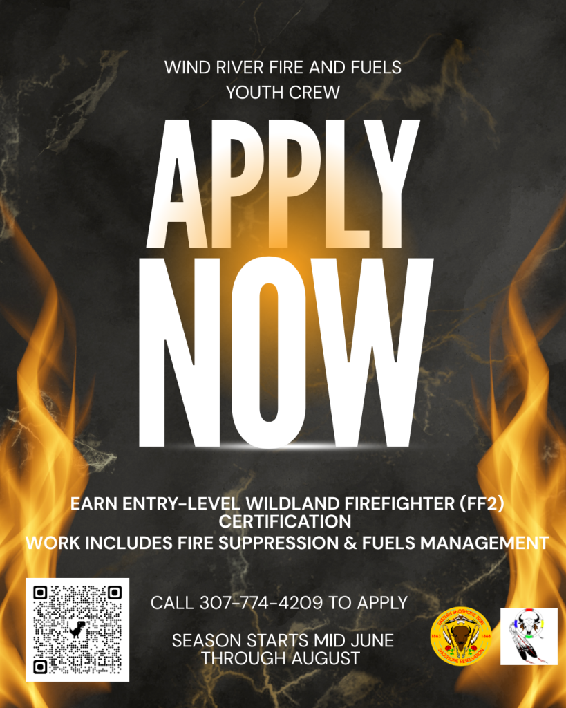
NOTICE!

06/25/07- Work Continues on the Monument Ridge prescribed burn. Firefighters and smoke will be seen in the area. 

- Monument Ridge Trail Closure - Map and Order
   - Monument Ridge Rx Information

Air quality is being monitored by PurpleAir sensors located in Bondurant, Pinedale, Hoback, and Jackson - Click Link to see sensor data 

No drones in fire zones! If you fly, we can’t. Flying drones or UAS within or near the prescribed burn area can put fire personnel at risk.

TIF Dispatch Area Preparedness and Staffing

Updated:
FDRA ERC BI FDR Forecast BI Forecast ERC Staffing Class Tomorrow's Response Level
Teton 40.3 31.2 M 29.9 39.1 4 Moderate
Wind 38.8 29.7 M 28.5 38.3 4 Moderate
Wyoming 39.2 32.4 M 30.6 39.5 4 Moderate

Bondurant, Wyo., June 25, 2024– The Bridger-Teton National Forest is continuing work on the Monument Ridge prescribed fire near Bondurant, Wyoming. The prescribed fire activities began on June 7, 2024. The Forest firefighters worked their way through the project area burning 3500-acres in total, over 10-days, while the weather and other factors were favorable for the treatment. The purpose of the prescribed fire is to help protect homes and property in the area. Fuel reduction at the interface between natural lands and developments can reduce the intensity of the fires before they enter populated areas. The firefighters began patrolling and mopping up the prescribed fire earlier this week.

Continue reading


Work on Monument Ridge Prescribed Fire Continues - Firefighters and smoke will be seen in the area

Western Wyo., June 25, 2024 — Teton Interagency fire managers announced the fire danger has been elevated to “moderate” for Grand Teton National Park, Bridger-Teton National Forest, and the National Elk Refuge. The potential for fire activity has increased due to summer curing of vegetation combined with warmer and windy conditions.

A moderate fire danger rating means fires can start from most accidental causes. Unattended campfires and brush fires have potential to escape, especially on windy days, in dry, open areas.

When determining fire danger, fire managers use several indicators such as the moisture content of grasses, shrubs, trees, and dead and downed materials; projected weather conditions including temperatures and possible wind events; the ability of fire to spread after ignition; and availability of firefighting resources both locally and nationally.

As the Independence Day holiday approaches, visitors and local residents alike are reminded that fireworks are not permitted in Grand Teton National Park, on the Bridger-Teton National Forest, within the National Elk Refuge, or in Sublette and Teton counties in Wyoming. These fireworks regulations play a critical role in fire prevention.

As we approach the Fourth of July holiday, visitors are reminded that personal fireworks are never allowed and that campfires must always be attended and cold to the touch before abandoning. To extinguish a campfire, several gallons of water must be used as opposed to a single water bottle. The process requires you to soak the campfire, stir the ashes, feel for heat, and to repeat the process until no heat remains. 

When enjoying a campfire, remember it should always remain attended and must be completely extinguished before leaving. Simply pouring water on the remains of a fire is not sufficient. The charred remains must be repeatedly doused with water and stirred into the campfire ring. All embers and logs, not just the red ones, should be broken up and covered with dirt. Before leaving the area, the campfire remains must be cold to the touch.

Visit the Teton Interagency Fire website at TetonFires.com to learn more about fire safety and what fire regulations may be in place. To report a fire or smoke in the immediate area, call the Teton Interagency Fire Dispatch Center at 307.739.3630.

###

USDA is an equal opportunity provider, employer and lender.

Fire Danger Increased to Moderate

Wildland and Prescribed Fire Map

Basin Creek RX

42.258788, -110.767152
Prescribed Fire

Nugent Park

42.170133, -110.80599
Prescribed Fire

Monument Ridge

43.200057, -110.433591
Prescribed Fire