Mobile Menu
SWCC Home
National
About Us
Site Disclaimer
Contact Us
SW Dispatch Center Websites
Arizona
- Arizona
- Phoenix
- Prescott
- Tucson
New Mexico
- Albuquerque
- Alamogordo
- Silver City
- Taos
INCIDENT INFORMATION
Fire Information
- Arizona
- New Mexico
InciWeb
- Arizona
- New Mexico
Fire Restrictions
LOGISTICAL OPERATIONS
Dispatch
Aviation
Crews
Equipment / Supplies
Overhead / Teams
PREDICTIVE SERVICES
Intelligence
Weather
Fuels / Fire Danger
Outlooks
FIRE MANAGEMENT & ADMINISTRATION
SW Coord. Group (SWCG)
- SWCG Committees
Agency Administrator
Critical Incident Stress Management
Incident Business Management
Safety Management
Software Applications
Training
- Priority Trainee Program
RELATED LINKS
Southwest Area
National
FUEL MOISTURE (DEAD)
FIRE DANGER
(FIRE FAMILY PLUS)
ERC Charts
SW Fire Environment Report
SW FIRE ADVISORIES
None at this time.
National Fire Advisories Webpage
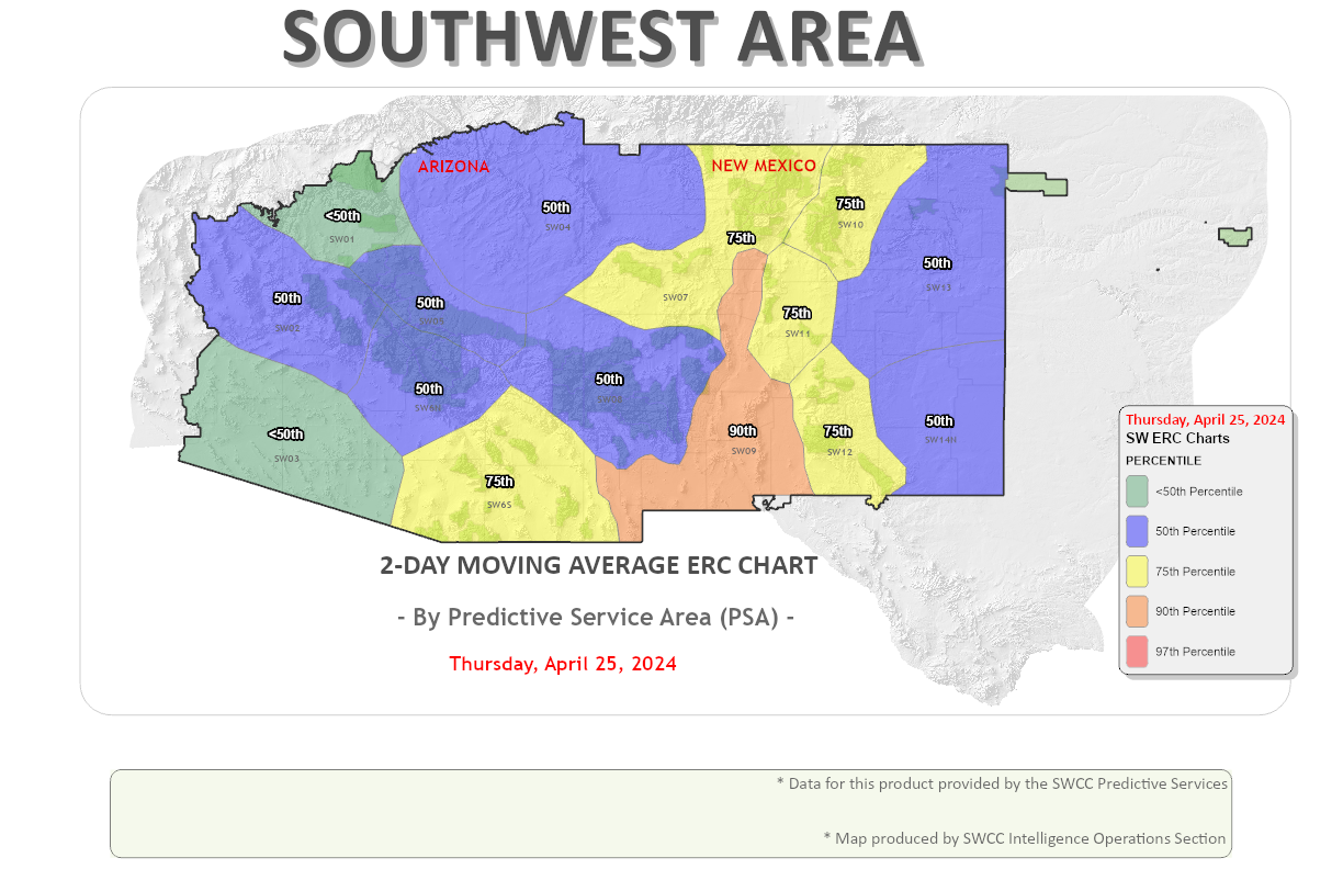
SW Energy Release Component (ERC) Charts
SW NFDRS Plans
Arizona Southeast Zone (SEZ)
Fire Danger Operating Plan
Staffing Plan
Response Plan
Prevention Plan
NATIONAL
ERC/BI/Fuel Moisture Charts (By PSA)
Daily NFDRS Observations
24-Hour NFDRS Forecast Obs
U. S. Geological Service
Fire Danger Forecast
-
Viewer
University of Arizona Products
Southwest U.S. NFDRS Charts
Southwest U.S. Burn Period Tracker
NATIONAL FUEL MOISTURE DATABASE (NFMD)
NFMD Website
CHANGE Password
How to Set Up a Sample Site in the NFMD
List of Current SW Sample Sites
How to Add Historical Fuel Moisture Data
YTD Reports
Arizona
New Mexico
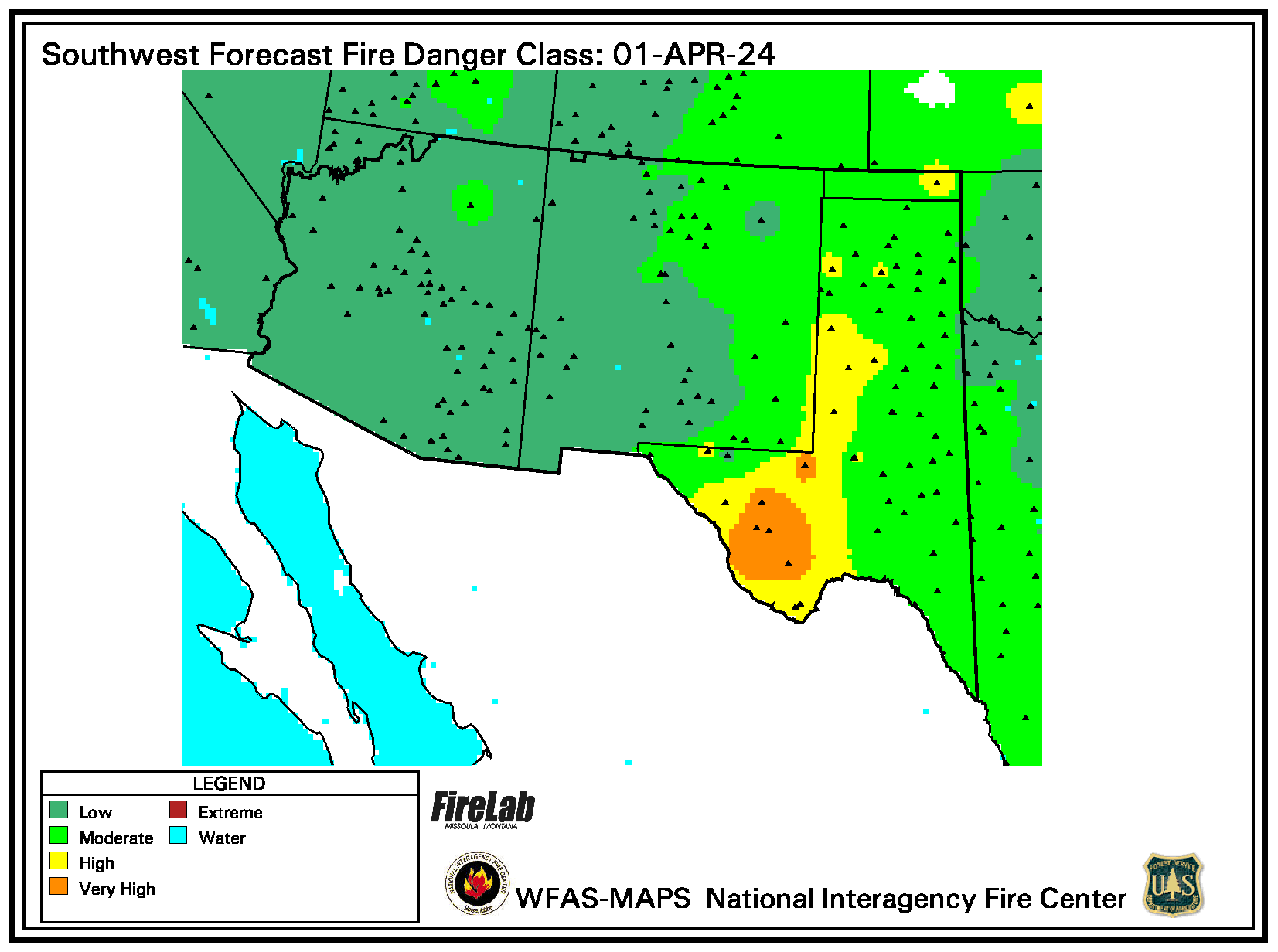
SW Forecast Fire Danger Class
NATIONAL
Wildland Fire Assessment System (WFAS.net)
FIRE DANGER / POTENTIAL
Forecast Fire Danger
FUEL MOISTURE
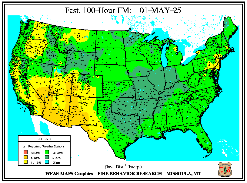
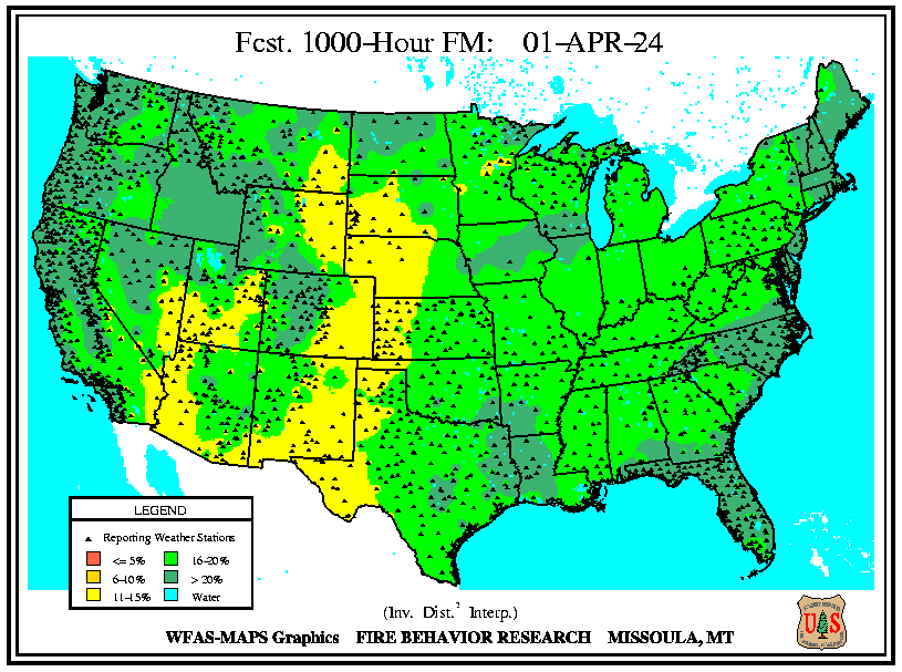
Forecasted:
10
|
100
|
1000
Wildland Fire Decision Support (WFDSS)
WFDSS and Data Exchange (iRWIN)
WFDSS Videos
National Pocket Card Website
Other Geographic Area Coordination Center Fuels / Fire Danger Pages
SOUTHWEST COORDINATION CENTER
333 Broadway SE
Albuquerque, NM 87102
Arizona Dept. of Forestry and Fire Management
Bureau of Indian Affairs
Bureau of Land Management
National Park Service
New Mexico State Forestry
U. S. Fish & Wildlife Service
U. S. Forest Service
Home
About
Site Disclaimer
Contact Us


![[Graphic] Fuels/Fire Danger](../../images/U1_PS_Fuels.gif)
![[Graphic] - SWCC Fire Weather Products](../../images/v_ps_wx_swcc.gif)

![[Graphic] - Fuel Moisture Program](../../images/v_ps_fuels_moisture.gif)


