REPORT WILDFIRES
Contact
TO REPORT A WILDFIRE:
- Contact Boise Dispatch at (208) 384-3400
- Contact the local fire department
- Contact the local county sheriff's office
- Dial 911 or #fire
For general information contact Boise Dispatch at (208) 384-3398, or email the dispatch center at idbdc@firenet.gov for additional information.
Office Hours
FIRE SEASON (June-October):
- The center is staffed seven days a week from 7:00 AM to 6:00 PM.
- Dispatch remains open for extended staffing as fire activity dictates.
SHOULDER SEASON (November-May):
- The center is staffed Monday to Friday from 8:00 AM to 4:30 PM.
- Dispatch staff is on-call and available after hours.
Fire Danger
National Fire Danger Rating System (NFDRS)
The National Fire Danger Rating System describes conditions that reflect the potential, over a large area, for a fire to ignite, spread, and require suppression action. The NFDRS utilizes expected (forecasted) indices to estimate the potential fire danger for a given day. The key inputs into the NFDRS model include: fuels, weather, topography, and risks.
The NFDRS links an organization's readiness level (or pre-planned fire suppression actions) to the potential fire problems of the day. The National Fire Danger Rating System assists fire managers with planning throughout the fire season.
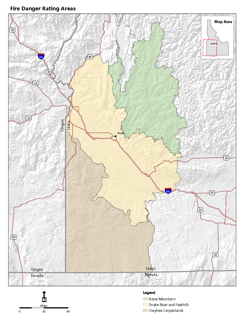
Fire Danger Rating Area (FDRA)
A Fire Danger Rating Area (FDRA) is a geographic area of relatively homogenous climate, fuels, and topography, tens of thousands of acres in size, within which the fire danger may be assumed to be uniform. An FDRA is the basic on-the-ground unit for which unique fire management decisions are made based on fire danger ratings. (Image Credit: Boise Interagency Dispatch Center)
To the right is the Fire Danger Rating Areas map that depicts those areas where management decisions are made including pre-planned fire suppression actions, staffing levels, and local area draw-down. Boise Interagency Dispatch Center has identified 3 Fire Danger Rating Areas within its dispatch zone:
BOISE MOUNTAINS
SNAKE RIVER and FOOTHILLS
OWYHEE CANYONLANDS
PocketCard
The NFDRS PocketCard is a tool utilized by wildland firefighters to track the fire danger and fire potential for a given Fire Danger Rating Area throughout the fire season. The PocketCard is created by analyzing the historic weather and fire occurrence for a localized area, or a Fire Danger Rating Area. The PocketCard illustrates the fire potential for the FDRA and identifies combinations of local weather and fuel conditions (local thresholds) that may contribute to extreme fire behavior.
PocketCard
Fire Danger Indices
- GBCC ERC & BI Y and SW ID NFDRS Spreadsheet
Fire Danger Operating Plan
- Boise Interagency Dispatch Center
| PREPAREDNESS LEVELS | Local (BDC) | Great Basin (GBCC) | National (NICC) |
|---|---|---|---|
| 2 | 4 | 5 |
| FORECASTED INDICES | Energy Release Component (ERC) | Severe Fire Danger Index (SFDI) | Dispatch Level (DL) | Preparedness Level (PL) | Fire Danger (FDR) |
|---|---|---|---|---|---|
| Boise Mountains | 47 | 85 | M | 1 | H |
| Snake River/Foothills | 54 | 83 | M | 3 | E |
| Owyhee Canyonlands | 53 | 83 | M | 2 | VH |