Northern Rockies Predictive Services meteorologists monitor fire weather and National Fire Danger Rating System (NFDRS 16) components from a number of key stations in Idaho, Montana, Wyoming, and North Dakota and South Dakota.
ERC, 1000-hr fuel moisture, 100-hr fuel moisture and Burning Index graphs are generated according to Predictive Service Areas (PSAs), which are geographic areas of similar climate/fuels based on statistical correlation of RAWS data. |
| |
| • |
For geographic comparison we are using Fuel Model Y and Fuel Model V, depending on applicablity. ERC and 1000-hr fuel moisture are stable indexes that do not jump around from day-to-day, whereas 100-hr fuel moisture is more variable. All are good for monitoring the fire season. |
|
|
| |
|
| • |
The graphs are updated daily and show a trending average for the 2010-Present time period (heavy gray line). The 90th and 97th percentile values are shown as solid back horizontal lines. Seasonal traces for year-to-date (blue line) and other significant/record years (orange line) may also be shown. (Note: Some stations do not have data for all representative years; what is available is used). |
| |
|
| |
| Tiled
Thumbprint Images of All PSAs Graphs |
| |
|
|
|
| (Click
on PSA for specific ERC, 1000-hr
and 100-hr Fuel Moisture, and BI graphs) |
|
| |
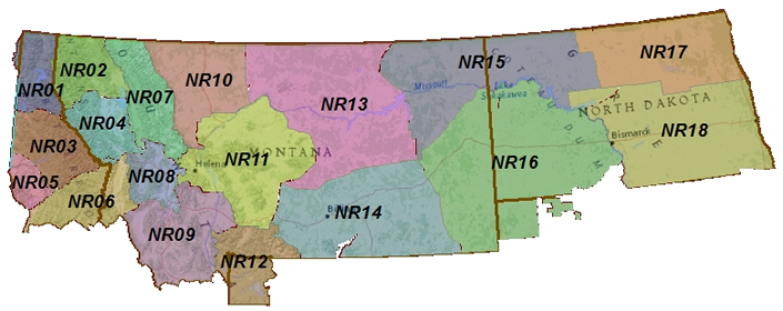
| Northern
Rockies Predictive Service Areas
(PSAs) |
(Click
on PSA # for particular ERC, 1000-hr,
and 100-hr Fuel Moisture, and BI graphs)
|
| |
|
|
| |
PSA
# |
PSA NAME |
| |
|
|
|
|
Northern Idaho Panhandle |
|
|
Northwestern Montana |
|
|
Southern Idaho Panhandle |
|
|
Western Montana |
|
|
Camas Prairie of
Idaho |
|
|
North Central Idaho
& Bitterroot/Sapphire Mountains |
|
|
Glacier National Park &
Wilderness Areas |
|
|
Southwest Montana,
West of Continental Divide |
|
|
Big Hole - Southwest
Montana, East of Continental Divide
|
|
|
Northern Front Range |
|
|
West Central Montana |
|
|
South Central Montana
& Yellowstone National Park |
|
|
Northern Plains &
Missouri River Breaks |
| |
|
Southern Montana
(Big Horn/Powder River) |
| |
|
Northeastern
Montana & Northwestern North Dakota |
| |
|
Southeastern Montana
& Southwestern North Dakota |
| |
|
Northeastern North
Dakota |
| |
|
Southeastern North
Dakota |
| |
| |