aztdc banner image
National Menu
  • Home
  • SWCC
  • National
  • Disclaimer
  • TRAINING
Primary Menu
  • Information
    • DAILY STAFFING
    • Incidents
    • Restrictions
    • Report a Fire
    • Local Logistics
    • WildfireAz
  • Operations
    • Aircraft
    • Cache
    • Crews
    • Dispatch
    • Equipment
    • Maps
    • Prescribed Fire
    • Prevention / Education
    • Forms
  • Predictive Services
    • Fuels and Fire Danger
    • Intelligence
    • Outlook
    • Weather
  • Fire Management and Administration
    • Agency Policy and Administration
    • Critical Incident Stress Management
    • Incident Business Management
    • Safety and Risk Management
    • Training

Fuels and Fire Danger

  • National Fire Danger Rating System (NFDRS)
    • Fire Danger Operating Plan Guidance
    • Fire Danger Pocket Card (Development, Approval, Viewing)
    • Gaining an Understanding of NFDRS
    • National Weather Service NFDRS Forecast Images
    • NFDRS Observations for Southeastern AZ
    • Point Forecast Tool - 7 day ERC
    • SEZ Interagency Fire Danger Operating Plan
  • Fire Behavior & Fire Danger Software:FireModels.org | Fire.org
  • Southeast Zone Fire Danger Information
  • Fuel Moisture Database (NFMD)
  • USGS LANDFIRE Data
  • USGS Vegetation Mapping
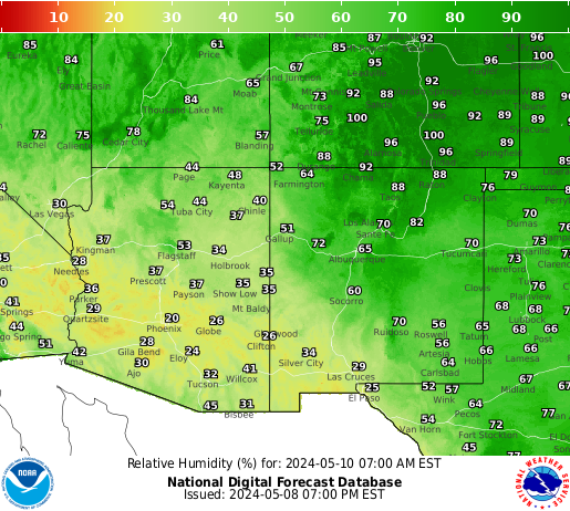
  • Wildland Fire Assessment System (WFAS)
    • Dead Fuel Moisture
    • Fire Danger Rating
    • Google Earth Fire Danger and Weather
    • Greenness Data
    • Growing Season Index
    • Live Fuel Moisture
2 Day Outlook
User account menu
  • Log in