
Observed: Friday 7/24/2026
|
Ignition Component |
Spread Component |
Energy Release Component |
Burning Index |
Adjective Rating |
Dispatch Response Level |
Staffing Level |
|
99th Percentile |
97th Percentile |
65th Percentile |
94th Percentile |
High |
Moderate |
4 |
Preparedness Level: 2
100 hr. Fuels: 11%
Forecasted: Saturday 7/25/2026
|
Ignition Component |
Spread Component |
Energy Release Component |
Burning Index |
Adjective Rating |
Dispatch Response Level |
Staffing Level |
|
94th Percentile |
90th Percentile |
69th Percentile |
88th Percentile |
High |
Moderate |
4 |
Preparedness Level: 2
100
hr. Fuels: 10%
Forecasted: Sunday 7/26/2026
|
Ignition Component |
Spread Component |
Energy Release Component |
Burning Index |
Adjective Rating |
Dispatch Response Level |
Staffing Level |
|
97th Percentile |
93rd Percentile |
73rd Percentile |
91st Percentile |
Very High |
High |
5 |
Preparedness Level: 2
100 hr. Fuels: 9%
** Forecasts can vary slightly from the time posted till the next 24 hour RAWS observation period**
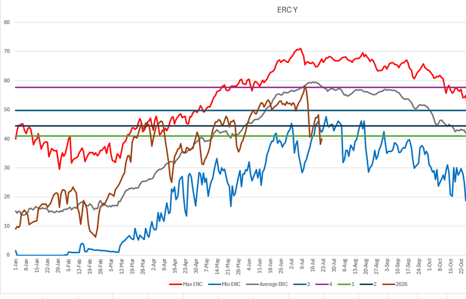
ERC Trend:
Forecast Discussion:
...RED FLAG WARNING IN EFFECT UNTIL 9 PM PDT THIS EVENING FOR PORTIONS
OF NE CALIFORNIA AND NW NEVADA DUE TO GUSTY WINDS AND LOW HUMIDITY...
...FIRE WEATHER WATCH IN EFFECT SUNDAY AFTERNOON AND EVENING FOR PORTIONS
OF NE CALIFORNIA AND NW NEVADA DUE TO GUSTY WINDS AND LOW HUMIDITY...
Gusty W/SW winds will combine with low daytime humidities for multiple
hours this afternoon in far NE California into NW Nevada. Areas of
elevated to critical wind/RH is also likely Sunday afternoon. Nighttime
recoveries will be poor across lower elevations of W Nevada through the
weekend. There is a low chance of afternoon showers and isolated storms
in Mono, S Lyon, Mineral, and Churchill counties this afternoon. Otherwise
seasonably hot and dry weather prevails through next week.