Annual Operating Plan for the Great Basin & NWS
- Introduction/
Changes - NWS
Roles - GBCC
Roles - Joint
Roles - Dates/
Signatures - Appendix A
WFOs - Appendix B
Directory - Print
Options
Introduction
This document serves as the Interagency Annual Operating Plan (AOP) for Fire Weather and Predictive Services for the Great Basin Geographic Area (GB). The general relationship between the National Weather Service (NWS) and the interagency fire management community is set forth in the National Interagency Agreement for Meteorological Services. This AOP provides specific procedural and policy information regarding the delivery of meteorological services to the fire management community within the GB as allowed under the umbrella of the National Agreement.
References include:- National Weather Service NWSI 10-4: Fire Weather Services (www.nws.noaa.gov/directives/010/010.htm)
- Interagency Agreement for Meteorological Services (National MOA or “National Agreement”) (http://www.myfirecommunity.net/NeighborhoodPosts.aspx?ID=531&Topic=2407&Category=1)
- Great Basin Mobilization Guide (http://gacc.nifc.gov/egbc/administrative/policy_reports/policy_reports.htm)
- National Interagency Mobilization Guide (http://www.nifc.gov/news/mobguide/index.html)
I. SIGNIFICANT CHANGES FOR 2015
- Weather Forecast Offices Grand Junction, CO and Salt Lake City, UT have now aligned fire weather zone responsibility with their County Warning and Forecast Areas.
- Fuel status methodology will be changing to a semi-automated process for the upcoming fire season.
- Eastern and Western Great Basin Centers are now combined into the Great Basin Coordination Center. See GACC responsibilites tab for more information.
- Red Flag Criteria for the shoulder seasons is clarified in the NWS responsibilities tab.
II. ORGANIZATIONAL DIRECTORY
Cooperating federal and state land management agencies in the Great Basin include:
| Bureau of Land Management | USDA Forest Service | US Fish and Wildlife Service |
| Bureau of Indian Affairs | National Park Service | Nevada Division of Forestry |
| Utah Forestry, Fire and State Lands | Idaho Department of Lands |
Fire weather products and services are provided by Great Basin Predictive Services and the following NWS offices within the NWS Central and Western Regions:
| Boise, ID | Flagstaff, AZ | Grand Junction, CO | Las Vegas, NV |
| Pocatello, ID | Riverton, WY | Salt Lake City, UT | Elko, NV |
| Reno, NV |
Service area information Predictive Services and each NWS office is available in Appendix A. A condensed contact information list can be found in Appendix B. NOTE: All phone numbers are unlisted and should not be given to the general public.
National Weather Service - Services And Responsibilities
I. Basic Services - A. Required Core Grids
I. BASIC SERVICES
Basic services constitute the collective suite of operational fire weather forecast products and professional services provided by the NWS. Any changes to these forecast services or implementation of new operational forecast products and/or services will be coordinated with the GB Predictive Services Unit (PSU) (Reference NWSI 10-403) and with local land management officials within the County Warning Forecast Area (CWA) of the NWS office that is proposing the changes. Any non- operational forecast products will be clearly labeled as “Experimental”.
A. Required Core Grids and Web-based Fire Weather Decision Support
National Digital Forecast Database (NDFD) grids are used to produce a wide variety of products and services for fire weather support Operational status of NWS grid elements is available at the following website: http://www.weather.gov/ndfd/resources/NDFD_element_status.pdf.
All NWS offices produce a digital forecast database that provides a variety of web accessible planning tools for fire weather partners. These tools can be of assistance to help determine the timing for a spot forecast request and include:
- Fire Weather Forecasts (FWF)
- Point Forecast Matrix (PFM)
- Digital Point Forecast
- FARSITE
- Weather Activity Planner
- Hourly weather graphs
- 48 Hr Element Meteorogram
These tools are all available at any time via links on top of NWS office fire weather web pages. NWS offices may also produce other tools for their area of responsibility. If you have questions, ideas or need more information on digital planning tools, please contact your nearest NWS office listed in this AOP.
I. Basic Services - B. Red Flag Warnings
B. Red Flag Warnings and Fire Weather Watches
The Red Flag Warning and Fire Weather Watch program is designed to provide land management officials with advanced notice of weather conditions that, when coupled with critical fuel conditions, can lead to extreme fire behavior or heightened potential for large fire starts. It is implicit that firefighter and public safety are of the utmost importance. Identification of Red Flag events is a shared, collaborative responsibility between land management officials and NWS fire weather forecasters. Weather forecasters must identify weather conditions that will contribute to extreme fire behavior or heightened large fire potential and land managers must provide information on the critical nature of fuels.
A Red Flag Warning shall be issued when Red Flag weather criteria (defined below) are forecast to occur within the next 24 - 48 hours or are already occurring, and are coupled with critical fuel conditions. Longer lead times are encouraged when confidence is very high or the fire danger situation is critical.
A Fire Weather Watch shall be issued when there is a high potential for Red Flag weather criteria to be met in the 18 - 96 hour time frame. The watch may be issued for all or selected portions within a fire weather zone or region.
1. Criteria
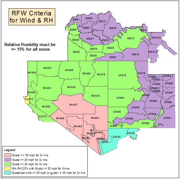
Standardized criteria for issuance of Red Flag Warnings and Fire Weather Watches in the GB are a combination of weather and critical fuel conditions. These warnings can be issued for either dry and windy conditions, or when an elevated threat of fire causing lighting is expected given that the fuels are critical. These criteria can also be combined.
The criteria for wind and relative humidity vary across GB:
The criteria for lighting based warnings vary across GB:
These criteria assume the following:
- Fuels must be critical. Two sources of information exist for NWS weather forecasters to acquire the status of fuels: the 7-Day Dryness Levels produced at GBCC and the Critical Fuel Status webpage that is updated by local fuel specialists. Each WFO can choose which method or combination of methods will be used to determine the fuel status.
- 7-Day Fire Potential Dryness Levels: If the Dryness Level is either Dry (yellow) or Very Dry (brown) for the PSA in which the FWZ lies the fuels can be considered critical for Red Flag Warning purposes.
- Critical Fuel Status: The fuel condition for each FWZ within GB will either be set as critical or non-critical during fire season. Please see the link below if using this method for determining the status of the fuels.
- Wind gust speed must be from NWCG compliant RAWS stations (20-foot) or a NWS/FAA ASOS station (10 meter). Wind gust speed measurements from other observation platforms will be used upon agreement between NWS and land management agencies.
2. Product Format and Content
A Red Flag Warning/Fire Weather Watch statement (RFW) will be used for issuing, updating, and canceling all Red Flag Warnings and Fire Weather Watches. This message will include:
- Headline that includes a description of the watch or warning, a description of the area (i.e., fire weather zones, counties, agency administrative unit, etc.), and the time period for which the watch or warning is valid in bulleted format.
- Short discussion detailing the causes and nature of the event.
- Please provide feedback about this format along with any questions to your local WFO throughout the fire season.
3. Procedures and Access
When Red Flag Warnings and Fire Weather Watches are issued, they will be headlined in both the fire weather planning forecast and any subsequent spot forecasts. In the planning forecast, the headline shall appear at the beginning, before the discussion section, and at the beginning of each zone or zone grouping affected by the warning or watch. The headline will be in the same descriptive format as on the RFW product itself. If issuance of a Red Flag Warning or Fire Weather Watch requires an update of the planning forecast, the NWS office will notify the affected dispatch centers and the GB PSU as soon as possible during business hours.
Red Flag Warnings and Fire Weather Watches will remain in effect through the expiration time noted in the planning forecast, or until canceled or updated.
Red Flag Warnings and Fire Weather Watches can be accessed through the various NWS offices that serve the GB, the GB PSU web site, and WIMS. Links can be found in Appendix A.
At a minimum, when either a Red Flag Warning or a Fire Weather Watch is in effect, there will an expanded FIRE WEATHER portion in the Area Forecast Discussion (AFD) issued twice daily from each NWS office. The AFD allows NWS offices to portray uncertainty and expand on reasoning beyond what is in other products. The Area Forecast Discussion is available on each NWS office's website.
I. Basic Services - C. Spot Forecasts
C. Spot Forecasts
Spot forecasts are site-specific forecast products issued for wildfires, prescribed burns, aerial spraying, HAZMAT incidents, search and rescue, and other land management activities. Spot forecasts are available by request, 24-hours a day, 365 days a year. They are available to any federal, state, county or municipal agency as described in NWSI 10-401.
The priority for spot forecast issuances and updates is described in NWS Western Region Supplement 14-2003, Prioritizing Products and Workload Activities for Western Region Forecast Offices.
Site-specific forecasts are considered one-time requests. Updates will be issued when:
- The forecaster determines that the current spot forecast does not adequately represent current or expected weather conditions, or;
- Land management personnel communicate to the forecaster that the current forecast is unrepresentative of conditions at the site, or;
- A typographical or formatting error is detected and could confuse the intended meaning.
Updates will be disseminated to users in the same manner as the original spot forecast. If the update is initiated by the NWS, a follow-up phone call will be made to inform the user (i.e., the original requestor) that an update has been issued. If the update is requested by the user, a contact point number will be provided.
Spot forecasts can be requested from individual offices:
Spot request instructions are available here: http://www.wrh.noaa.gov/lkn/spotrequestmain.php.
1. Content and Format
Spot forecasts may contain the following elements as requested by the user.
| Forecast Element | Requirement | Remark |
|---|---|---|
| Headline | National | Required if watch or warning is in effect when spot is issued. |
| Discussion | National | |
| Sky/Weather | National | |
| Temperature | National | |
| Relative Humidity | National | |
| Wind - 20ft, 10-min ave. | National | |
| Transport wind, mixing height, LAL, Haines, Chance of wetting rain, etc. | By request | Request made via NWS Spot web interface or Spot Forecast Request Form D-1 |
| HYSPLIT Trajectories | By request | Request made via NWS Spot web interface. See #3 below for more detailed instructions. |
The valid time will be determined at the time of the request. Most spots contain three periods, usually “TODAY”, “TONIGHT”, and “TOMORROW” but users will indicate the period(s) for which a forecast is needed in their request.
2. Procedures for Requesting Spot Forecasts
Internet-based NWS Spot is the standard for requesting and retrieving spot forecasts and should be used when available. It is accessible via web sites of the NWS offices that serve the GB and on the GB Predictive Services web site, found in Appendix B.
When Internet access is not available, spot forecasts may be requested and disseminated via fax - using spot forecast request form D-1 (NWSI-401). Spot forecasts should be available within 60 minutes of the time the NWS office receives the request. If a spot forecast is not returned within 60 minutes, the requestor should contact the NWS office immediately. Spot forecasts should be requested no more than 24 hours in advance. (WGB AOP says 48 hours)Beyond this time, planning information should be used, including the fire weather planning forecast, weather activity planner and fire weather point forecast matrix. For large burn plans, please coordinate multiple spot forecast requests with your local NWS office. It is strongly recommended that the requestor indicate the time he or she needs the forecast returned. If not specified in a spot forecast request, the NWS assumes the forecast is needed immediately.
The requestor must provide information about the location (latitude/longitude), slope aspect, drainage name, fuel type(s), top and bottom elevations of fire or project (if appropriate), size of fire or project, ignition time (if appropriate), and a contact name(s) and telephone number(s) of the responsible land management personnel. It is critically important that each spot forecast request also include quality, representative observations at, or near, the site or from a nearby representative RAWS station. A detailed description of the observation location relative to the project (if not at the site) should be provided. The description should include, at a minimum, distance and direction from the project or fire site, station elevation and aspect.It is preferable to have observations that indicate maximum and minimum temperature and humidity conditions near the fire location.
3. HYSPLIT Trajectories Request
HYSPLIT Trajectories is a model which determines trajectories for parcels at a given height above ground level. An easy method has been developed to take advantage of the base information that is already input into the spot request form to generate automated HYSPLIT Trajectory forecasts. The HYSPLIT trajectories can be used for many purposes (i.e. HAZMAT, smoke, etc.).
The HYSPLIT output represents computer model forecasts without any human interaction. They do not take into account information on burn size or fuels, thus generate trajectory forecasts for 500, 1500, and 3000 meters AGL without regarding whether fire plume height will reach that altitude.
To utilize this feature, simply add the word Hysplit and your email address into the remarks section of a spot request:
example Hysplit to first.last@noaa.gov
You will receive an email that consists of a table of values, a GIF Hysplit trajectory map, and a KMZ trajectory map for loading into Google Earth.
It is recommended that you try this procedure and get a feel for its content before using it for actual guidance on a burn or fire.
For more information, please visit http://www.arl.noaa.gov/HYSPLIT_info.php. If you have any questions, please contact your local fire weather program leader. >
4. Spot Forecast Feedback Requirement
Good communication between fire managers and the NWS is critical for quality spot forecast services. Land management personnel should provide feedback to the NWS forecasters about the quality and accuracy of the spot forecast. Feedback should also be relayed to GACC meteorologists. Responsibility for providing fire line observations for the verification of forecast accuracy rests with the land management agencies, as outlined under, “Fire Weather Observations,” under Joint Roles in this AOP, and is to be provided via the online spot request form.
I. Basic Services - D. National Fire Danger Ratings System
D. National Fire Danger Ratings System (NFDRS) Forecasts
The National Weather Service will provide National Fire Danger Ratings System (NFDRS) forecasts valid at 1300 LST (1400 LDT) the next day after issuance. These forecasts are used to prepare the NFDRS fire danger indices for the next day. Stations that do not have valid observations in WIMS on time will not receive an NFDRS weather forecast and, thus, will not receive forecast fire danger indices for the next day.
1. Criteria for Issuane
NWS will issue NFDRS forecasts daily when NFDRS-compliant observations are received. Edited NFDRS observations must be complete and available in WIMS by 1350 LST (1450 LDT) to be received by NWS in time to produce a forecast.
- If the unofficial or ‘R’ type 1400 LDT observation is available in WIMS or ROMAN an NFDRS forecast can be created and sent back to WIMS. Forecasts must not be sent to WIMS before the unofficial 1400 observation is received in WIMS/ROMAN because NFDRS forecasts will use yesterday’s observation to calculate the NFDRS indices, which is incorrect.
2. Content and Format
The content and format shall comply with NWSI 10-4. Each NFDRS forecast shall also include the 24 min and max temperature and relative humidity forecast and shall not include the 10 hr fuel moisture forecast. A wet flag of ‘yes’ should only be forecast if the forecaster is certain that precipitation will be of sufficient duration and amount to keep fuels wet or when expectation is that fuels will be snow covered. The actual NWS NFDRS forecast product is used only by WIMS and is not viewable directly by fire management personnel.
3. Procedures
Each WFO shall produce individual NFDRS station (point) forecasts. Valid observations must appear on the 1400 LST (1500 LDT) observation collective or forecasts will not be generated. A second collective is generated around 1530 LDT to catch any missed (late) observations. Forecasts may be in the form of a trend forecast for individual stations or grouped stations (zones), or a point (station-specific) forecast. However, the form used should be coordinated with local land management officials and Predictive Services at the GACC. When point forecasts are issued, NWS will ensure that forecast values are statistically valid relative to climatological values for those stations. When using the trend forecast format, there may be rare instances in which weather conditions require separate point forecasts be issued for one or more of the grouped stations. This should be a temporary change to be used only while meteorological conditions require.
I. Basic Services - E. Planning Forecasts
E. Planning Forecasts (FWF)
Planning forecasts (or preparedness forecasts) are issued by all NWS WFOs offices serving the GB. These forecasts provide general, zone-based information used in daily planning and preparedness.
1. Issuance Times During Fire Season
Two forecasts will be issued daily – a morning forecast issued no later than 0730 local time and an afternoon forecast issued by 1530 local time – 7 days a week during the fire season. Twice per day fire weather forecast requirements will normally run from the first Monday in May to the last Friday in October, with sub-regional variations dependent on weather, elevation and latitude. Local start and stop dates shall be coordinated between the NWS offices and fire weather customers, including the geographic area Predictive Services Units. Modifications to these start and stop dates are enumerated in Appendix B, National Weather Service Offices.
2. Issuance Outside Fire Season
Some NWS offices issue fire weather planning forecasts year-round. NWS offices issue fire weather planning forecasts year-round, however offseason forecast may not be as detailed as those issued during the fire weather season. However, all NWS offices will issue spot forecasts upon request at any time of year.
3. Forecast Updates
Forecasts will be updated for the first 36 to 48 hour time period when: 1) A Fire Weather Watch or a Red Flag Warning is issued, cancelled, or updated; 2) when any of the amendment criteria in Table 1 are met over a meteorologically significant area; or 3) typographic or formatting errors that confuse the intended meaning are detected.
| Forecast | AMEND when... |
|---|---|
| No thunderstorms forecast. | Thunderstorms occurring or are imminent prior to the next routine planning forecast issuance. |
| Wind speed of 15 mph or greater. | Speed exceeds forecast by 10 mph or more. |
| Average minimum RH is 16% to 40%. | Differs by 10% or more. |
| Average minimum RH is 15% or less. | Differs by 5% or more. |
The NWS forecaster should notify all impacted Dispatch and Communications Centers when the forecast has been updated. The forecaster should also notify the Meteorologist or the Coordinator on Duty (COD) at the GACC. When notifying the GACC, do not use voicemail during normal business hours (published in Appendix B). During non-business hours (i.e., overnight), no special notification is necessary.
4. Access
Forecasts are transmitted automatically to the Internet. Forecasts can be accessed through the various NWS offices that serve the Great Basin, the GB PSU web site, and WIMS. Links can be found in Appendix B.
5. Content and Format
Forecasts will conform to the national standard narrative format, per NWSI 10-401. Morning forecasts will focus on the following 36 hours (3 operational periods). Afternoon forecasts will focus on the following 48 hours (4 operational periods). General extended outlooks will cover, at a minimum, the next 5 calendar days. (General extended outlooks will cover, at a minimum, the 3 to 7 day forecast period.)
Each forecast will begin with pertinent headlines and a brief, non-technical weather discussion highlighting significant weather events or critical fire weather patterns. Headlines are required for Red Flag Warnings and Fire Weather Watches and are encouraged for other significant fire weather elements that do not meet Red Flag criteria. Affected zone segments of the planning forecast must also include the appropriate headline.
Forecasts for the first 36 or 48 hours will contain the elements shown in Tables 2 and 3 below for each zone or zone grouping, listed in the order they will appear. Format examples and descriptions of forecast elements can be found in the appendices.
| Forecast Elements and Order | Requirement | Remarks |
|---|---|---|
| Headline(s) | National | As appropriate |
| Sky/Weather | National | |
| Temperature and optional 24-hour trend | National | In complex terrain, temperature and RH should be forecast at discrete elevations (e.g., 3000-ft, 5000-ft, 8000-ft, etc.) or at generally accepted locations (i.e., valley bottom, mid-slope, etc.). These should be coordinated with the local land management agencies and Predictive Services. |
| Wind - 20-ft RAWS standard (slope/valley) | National | Wind speed must conform to the NWCG standard of 20-ft, 10 min. average wind. . Additionally, forecast ranges should not exceed 10 mph. Wind gust speed must be from NWCG compliant RAWS stations |
| Wind - Ridgetop (as appropriate) | National | Wind speed must conform to the NWCG standard of 20-foot, 10-minute average wind. Additionally, forecast ranges should not exceed 10 mph. Wind gust speed must be from NWCG compliant RAWS stations |
| Chance of Wetting Rain (0.10 inch) | Great Basin | |
| Lightning Activity Level (LAL) | Great Basin | As defined in Table 4. |
| Haines Index | Great Basin | |
| Mean Mixing Height | Optional | |
| Meant Transport Wind | Optional | |
| Ventilation Index (kt-ft) | Optional | |
| Extended forecast to day 7 | National | One extended forecast at end of planning forecast or each zone, per local agreement. |
| LAL | Description | Areal Coverage |
|---|---|---|
| 1 | No lightning. | |
| 2 | Isolated wet or dry thunderstorms. | Less than 15% coverage. |
| 3 | Widely scattered wet thunderstorms. (Isolated wet thunderstorms.) | 15% to 24% coverage. |
| 4 | Scattered wet thunderstorms. | 25% to 54% coverage. |
| 5 | Numerous wet thunderstorms. | 55% to 100% coverage. |
| 6 | Widely scattered or greater dry thunderstorms. (Isolated or greater dry thunderstorms.) | 15% or greater coverage. |
I. Basic Services - F. Scheduled WFO Backup/Extended Radar Outage
F. Scheduled WFO Backup/Extended Radar Outage
A. Backup Notification
Dispatch Centers will be notified of any scheduled backups by another WFO. The earlier the notification, the more beneficial this will be for the project manager’s decisions in planning for prescribed burns, as well as for coordination during wildfires. Daily reminders are recommended. If project managers/burn bosses still want to proceed with prescribed burns, planned for the day of backup, they should submit spot forecast requests before 0700 MDT, if they want their forecasts generated by the local WFO. Otherwise, forecasters from a different WFO (who have less expertise in the CWA) will produce the spot forecasts. The office performing the backup duties will be listed at the top of the forecast products.
B. Extended Radar Outage
Dispatch Centers, including EGBCC, will be notified of extended radar outages via a message in the NWS Chat room for fire weather, egbfirechat.
An example of a message regarding the Cedar City (Brian Head) radar:
FTMICX
Message Date: Mar 05 2012 17:36:27
KICX WILL BE DOWN PERIODICALLY THROUGHOUT THE DAY TODAY MARCH 5 2012 FOR MAINTENANCE.
Similar message will be available for all radar sites in the EGB area. For more information on the radars and NWS Chat, please consult your nearest NWS office.
II. Participating in Interagency Groups
II. Participation in Interagency Groups
A. Local Outreach Meetings
NWS offices should participate in at least one outreach meeting per year, usually prior to the start of the next fire season with local fire management units. These meetings can be used to strengthen the customer relationship, present new or changes to services and address local concerns. GACC meteorologists should be notified of these meetings and strongly encouraged to participate. Similarly, fire agencies should advise the GACC of fire weather meetings they are planning.
B. GACC Meetings
NWS WFOs and local Interagency Dispatch Centers within the GB should send a representative to the annual AOP meeting (if scheduled). Proxy representation is acceptable. A GACC-wide fall review meeting can be used to review the previous season, discuss what worked and what did not and identify issues to be addressed for the next Annual Operating Plan.
III. Special Services
III. Special Services
NWS will provide and maintain a cadre of trained Incident Meteorologists (IMETs). A sufficient number of IMETs should be available to support multiple incidents from May through September. Information regarding the dispatch of IMETs, both within and outside the GB, can be found in the Great Basin Mobilization Guide.
IV. Forecaster Training
IV. Forecaster Training
The NWS recognizes the need for specialized training in fire weather meteorology for forecasters. Any NWS meteorologist producing fire weather products shall have met the requirements set forth in NWSI 10-405.
Great Basin - Services And Responsibilities
A. Operational Support and Predictive Services
The GB Predictive Services Unit resides at the Great Basin Coordination Center. The GBCC's primary mission is to provide resource support for the functional areas of overhead, crews, aircraft, supplies and equipment to the field for wildland fire and other emergency operations.
A. Operational Products and Decision-Support Services
Predictive Services will produce a suite of products tailored to the tactical and strategic mission of the land management agencies within the GB. While the main area of responsibility is at the geographic area level, Predictive Services will provide services to sub-units of the geographic area, such as dispatch centers and local administrative units. Contributions will also be made to the national level Predictive Services program.
1. 7-Day Significant Fire Potential Outlook
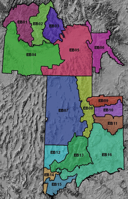
The 7-Day Significant Fire Potential Outlook addresses the potential for significant weather events (dry lightning outbreaks, precipitation events, wind events, etc.) that can impact fire occurrence or fire behavior in the next 7 days and that could require short-term decisions on resource availability and movements. The outlook will identify significant fire potential in a 3-category scale based on ERCs and 100-hour fuel moisture forecasts. Fire triggers (i.e., lightning, wind, Hot Dry and Unstable, etc.) will be incorporated to refine the potential on individual days. A map of PSAs within GB is included in Appendix B.
The outlook will be issued every morning – Monday through Friday and on weekends during critical fire periods - by 0900 MST/MDT, beginning May 1 and continuing through October 31. Seasonal start and stop dates may vary based on fire business needs and large fire potential. Updates will be made when it appears that observed or expected conditions are significantly different than those contained in the product.
More information on the 7-Day Outlook can be found on the Great Basin Predictive Services website. 7-Day Outlooks are archived daily.
2. Fire Potential Web Briefing
The briefing will be issued every morning – Monday through Friday and on weekends during critical fire periods - by 0900 MST/MDT, beginning May 1 and continuing through October 31. This breifing will focus on regional fire potential trends for the next 7-10 days.
3. Impact Map
The Impact Map is a text-and-graphics product which summarizes the highest impact fire potential conditions for the next 3-5 days.
The Impact Map will be issued every day – Monday through Friday and on weekends during critical fire periods beginning early May and continuing through October 31. Seasonal start and stop dates may vary based on fire business needs and large fire potential.
4. Monthly/Seasonal Fire Potential Outlook
The Monthly Fire Potential Outlook is a broader, more general assessment of weather, climate, and fuels conditions across the area. It incorporates climate trends, potential weather, and fuels condition and trends to make long-term predictions of impacts on fire business. Outlooks will focus on potential for large fire activity and time frames that will impact resource availability and mobilization relative to normal fire business for the time of year.
The Monthly outlook will be issued no later than 2 business days prior to the start of the month for which it is valid. Monthly outlooks will be produced by both the Predictive Services National Office and the GB PSU, following the same general format.
6. Fuel Status Tables and Map
The Fuels Status table and map is produced primarily to provide NWS forecasters with a snapshot of fuels conditions that would require a red flag warning or fire weather watch if weather conditions that would meet the red flag criteria (NWS Roles - Section B) are expected or are imminent. These do not replace the NFDRS observed and forecast indices for fire danger. Instead, the fuels status table and map highlight areas where fuel conditions would support large fire growth or extreme fire behavior as determined by fuels and fire specialists on the ground. The tabular and graphical information also do not preclude coordination between the NWS forecasters and the local land management agencies they serve.
The table will be updated regularly (preferably every 7-10 days) or immediately if fuels become critical by land management fuels specialists (or other designee). The map will automatically update to reflect what is displayed by the tabular data and will indicate when it was last updated.
7. Experimental Combined Lightning Potential/Fuel Dryness Graphic
The Combined Lightning Potential/Fuel Dryness Graphic continues to be an experimental product. It is generated by combining the Dryness Level information produced by the GACC with the Lightning Potential forecast produced by the NWS.
Product is hosted by the Storm Prediction Center. http://w1.spc.woc.noaa.gov/exper/ltgfuel/
SLC WFO will continue to issue the “Fuel Dryness and Lightning Probability Information” http://www.wrh.noaa.gov/slc/fire/Dryness/Dryness.php
9.Fire Indices Information
Predictive Services updates the current Energy Release Component (ERC), 100-hr and 1000-hr charts, which are available at the Great Basin Predictive Services Website: ERC - http://gacc.nifc.gov/gbcc/fuels.php
These charts track current Fire Danger conditions through a specified period of time and relate the current conditions to maximum, minimum and normal ranges. There is typically one or two additional reference years depicted on the charts, which are intended to either compare or contrast the current year. These charts are updated daily during fire season, generally beginning June 1 and continuing through October 31. These charts are also updated periodically during the off season.
These charts are updated daily during fire season, generally beginning May 1 and continuing through October 31, and are not updated during the off season.
B. Land Management Liaison
B. Land Management Liaison
Predictive Services meteorologists will act as a liaison on issues regarding weather, climate, and fuels between the land management agency partners in the GB and service providers in these areas, including the NWS, private sector providers, and the research community.
C. Monitoring, Feedback and Improvement of Fire Weather Information
C. Monitoring, Feedback and Improvement of Fire Weather Information
Land management agencies will monitor all sources of fire weather information to ensure quality, consistency, and applicability. When significant issues arise, Predictive Services will address the issue with the service provider to enhance awareness and to work toward an appropriate solution. Items of significance include, but are not limited to:
- General forecast consistency between County Warning and Forecast Areas (CWFAs), dispatch zones, and land management administrative units.
- Red Flag Warning and Fire Weather Watch consistency with established criteria, timeliness of issuance, coordination and applicability.
- NFDRS forecast consistency with station climate histories.
- Quality of fireline observations and spot forecast feedback from the field.
- Overall adherence to policy and procedure, especially as set forth in the AOP.
- Feedback from the field on the quality of all forecast products, especially Red Flag Warnings and Watches and Spot forecasts.
It is imperative that field personnel provide timely feedback to the NWS about products and services. This information will be used to gauge the quality and validity of products and services, make improvements and to resolve any conflicts or discrepancies between products issued. Feedback should be provided as soon as possible so that action can be taken immediately. Feedback may be positive or negative but it should always be constructive and intended to provide information that will help improve products and services. Comments can be submitted through Predictive Services or directly to the NWS (with a copy to Predictive Services).
D. Technology and Data Transfer
D. Technology and Data Transfer
Predictive Services will work to integrate advanced technology into analytical and prediction systems for use in fire management planning and operations. This will include regional numerical modeling, weather and fuels data assimilation and dissemination, and continued research and development in fire meteorology.
Where fire management computer systems, such as WIMS, are available, access will be granted to NWS for the purpose of obtaining and providing mission critical information, such as weather observations and forecasts.
E. Fire Weather Observations
E. Fire Weather Observations
Weather observations will be provided by the land agencies to the NWS to ensure sufficient information is available to produce quality forecast products. RAWS observations will comply with NWCG standards for quality and timeliness. RAWS will be sited and maintained in accordance with the NWCG PMS 426-3, “National Fire Danger Rating System Weather Station Standards.”
Weather observations at or near the fire or project site are highly recommended when requesting a spot forecast. If this is not possible, observations from a nearby, representative RAWS site may be substituted. Fireline observations are strongly preferred. Agency personnel should provide observations containing, at a minimum: temperature, humidity, wind speed and direction, and weather and sky condition that complies with guidance provided in NFES 2140, “Weather Station Handbook – an Interagency Guide for Wildland Managers.” Keep in mind that the quality of the observation, or how representative it is of conditions at the fire or project site, will affect the precision a forecaster can provide in a spot weather forecast.
For large or complex planned projects requiring spot forecasts, such as prescribed burns, aerial spraying, rehabilitation, etc., it is strongly recommended that observations be taken for a minimum of seven (7) days, 24 hours a day, prior to commencement of the project. This will provide forecasters with a history of diurnal variations of weather, temperature, humidity, and wind at or near the project site. For smaller, less complex projects, such as pile burns, observations should be collected for a minimum of two (2) days.
F. Incident Response
F. Incident Response
The NWS is the provider of Incident Meteorologists (IMETs). Predictive Services meteorologists can respond to incidents when the NWS cannot provide a certified IMET within 24-hours of request receipt by the National Fire Weather Operations Coordinator (NFWOC). In these instances, and when requested by incident command staff, Predictive Services meteorologists will provide forecast support as a Technical Specialist until the arrival of a certified NWS IMET. Technical Specialists will not be used as a substitute for NWS IMETs. Forecast support will revert to the NWS IMET after a reasonable transition period.
Joint Responsibilities
A. Briefings
Predictive Services or NWS meteorologists may be asked to provide briefings to agency decision- makers. These briefings generally occur during peak periods of the fire season or when a Multi- Agency Coordination (MAC) Group has been convened. The briefings usually include a short-term weather discussion of critical weather patterns and a longer-term discussion of trends during the next several days. The briefings provide tactical (operational) and strategic (planning) information for land managers.
Briefing schedules vary with planning and staffing levels, fire activity, and management priorities. Predictive Services will provide briefing schedules and conference bridge phone numbers, as needed.
B. Coordination Calls
GACC-wide weather and fuels coordination calls shall be held during the 2012 fire season. Attendees shall include GB Predictive Services, a representative from each NWS office and dispatched IMETS when available. Coordination calls will begin on a weekly basis on 6 June and continue each Wednesday. Calls will be held daily during periods of critical fire activity. Calls will take place at 1130 a.m. MDT on the GB conference call bridge (which will be sent via e-mail).
NWSChatNWSChat is an online chat tool available to help NWS Meteorologists and Fire Managers better communicate, especially during periods of active fire weather. Fire Managers must register online to be given a username and password. Each NWS office hosts a chatroom. There is also an 'GBC Fire Chat' Chatroom where all NWS offices within GB can post and fire managers througout the GACC can see updates. For more info on NWSChat Live and to request a username and login please see the website:
https://nwschat.weather.gov/live/C. Training
Training for weather sections of S-190, S-290, S-390 and other fire weather courses can be provided at customer request. Requests can be made at any time of year to any of the NWS offices in the Great Basin. Requests will generally be met unless there are scheduling or staffing conflicts at the NWS office. In these cases, the requesting person or agency should provide alternate dates. If this is not possible, the NWS will assist in locating another trainer from another NWS office, or as necessity dictates, from the GACC. Reimbursement for NWS instructor travel costs is required for all training requests.
Cross-training between NWS and GACC meteorologists is encouraged. NWS forecasters can detail at the GACC to gain an understanding of the decision support role Predictive Services fills in fire operations. GACC meteorologists can shadow NWS forecasters to view the forecast preparation process utilizing technologies available at NWS offices. Scheduling of cross-training visits should be arranged as far in advance as possible to reduce impacts on operations. However, because of the rapidly-changing nature of fire operations, the best opportunity may come with short notice. Flexibility is necessary.
D. Verification
Predictive Services and NWS meteorologists will cooperatively develop, perform, and report verification results of prepared fire weather products. These will include, but are not limited to: Red Flag Warnings and Fire Weather Watches; NFDRS point forecasts; 7 Day fire weather/fire potential outlooks. Data sources used in verification must be well-sited, representative of conditions being verified, and reliable. Data sources not listed explicitly in the AOP will be determined on a case by case basis by both NWS and Predictive Services meteorologists. Verification of Fire Weather Watches/Red Flag Warnings should generally occur within a few days of an event or a period of events. NWS and Predictive Services should discuss verification results at least annually at the end of the season to ensure consistent verification methods are used and to share lessons learned from each event.
E. Establishing or Modifying Forecast Zone Boundaries
Forecast zone boundaries shall be established and/or modified jointly by the NWS and the land management agencies with administrative responsibility for the affected lands. Predictive Services meteorologists should be included in negotiations. Existing zone boundaries may be modified to avoid splitting land management administrative boundaries between multiple NWS forecast areas. Changes must be agreed upon at least 120 days prior to implementation.
F. Remote Automated Weather Stations (RAWS) Monitoring
All Meteorologists should monitor the RAWS network for suspect or erroneous data, using sound meteorological judgment to determine if data is not representative of conditions. When an observation is identified as unrepresentative, forecasters should notify the EGB Predictive Services meteorologist to initiate maintenance or repair of the station in question. Predictive Services will relay information regarding the network to, address issues and concerns with, and offer recommendations for improvements to the network to the USDA Forest Service Regional RAWS coordinator and to the BLM-NIFC RAWS Program manager, as appropriate. Predictive Services will attempt to notify appropriate NWS offices of outages and restoration of services in a timely fashion, as time and human resources allow.
Effective Dates for the Annual Operating Plan
The effective period for this Annual Operating Plan shall be from 1 May 2014 to 30 April 2015. The AOP shall be deemed official when all signatories have accepted and signed the document. Updates or amendments may be added upon agreement of all signatories.
Signatures
________________________________
Sue Stewart
Chair, Great Basin Coordinating Group
USDA Forest Service
Director, Fire and Avaition Management, Region 4
Date:___________________________
________________________________
Bob Diaz
Meteorologist-in-Charge, Boise
Idaho State Liaison
National Weather Service
Date:___________________________
________________________________
Larry Dunn
Meteorologist-in-Charge, Salt Lake City
Utah State Liaison
National Weather Service
Date:___________________________
________________________________
Steven Apfel
Meteorologist-in-Charge,
Wyoming State Liaison
National Weather Service
Date:___________________________
________________________________
Gary Woodall
Meteorologist-in-Charge,
Arizona State Liaison
National Weather Service
Date:___________________________
________________________________
Rex McKnight
Chair, Great Basin Coordinating Group
Bureau of Land Management
Nevada State Fire Management Office
Date:___________________________
________________________________
Jon Mittelstadt
Meteorologist-in-Charge,
WFO Reno, NV
National Weather Service
Date:___________________________
Great Basin GACC
EASTERN GREAT BASIN
1. Changes for 2014 Season
See Main section of AOP for overall program changes.
2. Hours of Operation
Monday through Friday: 0730 to 1600.
Saturday and Sunday: As needed, 1 June through 30 September
EGBCC is open 1 May through 30 September 0600 to 1800 MDT. If need arises, request Coordinator-on-Duty (COD) to contact meteorologist if not on-duty.
3. Staff and Contact Information
See Appendix B.
Eastern Great Basin Fire Weather Zones

---------------------------------------------------------------------------------------------------------------------------
Eastern Great Basin Predictive Services Areas (PSAs)
Boise
NWS BOISE WEATHER FORECAST OFFICE
1. Changes for 2014 Season
NWS Boise will continue using the phrase “isolated” (<25% coverage, LAL 2 or 3) versus “widely scattered” when discussing thunderstorm coverage.
2. Hours of Operation
Once a day pre-fire season forecast issuance will begin Monday April 28th, but will be dependent on ongoing weather and fuel conditions. These forecasts will be issued Monday through Friday by 1530 MDT.
Starting dates for the full complement of fire weather products (including NFDRS forecasts and twice-daily zone forecasts) will depend on variables such as fuel dryness and customer needs. Typically, this occurs by mid to late May.
Staff meteorologists are available any time, 24 hours a day, 7 days a week. The fire weather desk is staffed from 0730 to 1530 MDT.
3. Staff and Contact Information
See Appendix B.
4. Fire Weather Services
A. Description of Boise Fire Weather District within Eastern Great Basin:
- West Central Idaho Mountains
- Zone 400: Northern Boise BLM
- Zone 401: Western Payette NF and SITPA
- Zone 402: Eastern Payette NF
- Zone 403: Northern Boise NF
- Zone 421: Southern Boise NF/W. Sawtooth NF
- Southwest Idaho
- Zone 423: Owyhee Mountains
- Zone 424: Shoshone BLM
- Zone 420: Treasure Valley
- Zone 426: Southern Highlands
B. Basic Meteorological Services
Weather Briefing: During the fire season, a daily briefing will be offered each day at 0930 MDT for all agencies via a GoTo Meeting. During pre-fire season and low fire activity periods it will be held on Mondays and Thursdays at 0930 MDT. This briefing will include a general discussion of weather conditions and forecasts for the current day, as well a brief discussion of the extended period. Model data, satellite loops, and other items of interest will be addressed for the forecast period. The briefing will usually be about 10 minutes but may be longer during active fire periods.
Spot Forecasts: Requests for spot forecasts will be received via the Boise Fire Weather homepage found at:
http://spot.nws.noaa.gov/cgi-bin/spot/spotmon?site=boi
Alternatively requests can be faxed to: (208) 334-1662
C. Product Schedule
| Morning Fire weather forecast | By 0830 MDT |
| Weather Briefing | At 0930 MDT |
| Afternoon fire weather forecast | By 1530 MDT |
| NFDRS point forecasts for Mountain time zone stations | By 1530 MDT |
| Fire Weather Watch/Red Flag Warning | Event-driven |
| Spot Forecasts | On request |
D. Red Flag Events
Interagency Coordination: Before the issuance of a Red Flag Warning, there will be coordination with the affected agencies and neighboring NWS fire weather offices in order to assess fuel conditions and general fire danger. This coordination will conducted either during the internet briefing and/or a separate phone call.
Dissemination of Fire Weather Watches and Red Flag Warnings: Each issuance, update or cancellation of a Fire Weather Watch or Red Flag Warning will be relayed by telephone to the dispatch offices and GACCs affected by the watch or warning.
Criteria for Red Flag Warnings and Fire Weather Watches:
High to extreme fire danger in conjunction with dry fuels. (Dryness level yellow or brown, as defined by the Eastern Great Basin Geographic Coordination Center 7 day Fire Potential Outlook and/or agency input.)
http://gacc.nifc.gov/egbc/outlooks.php and/or http://199.141.1.20/fuels/egb/public/
in combination with the following weather conditions:
- Abundant lightning. Aerial coverage must be at least scattered (>25%) in nature. LAL>4 and/or
- Wind gusts > 30 mph for 3 hours or more; and relative humidity <15%...EXCEPT > 25 mph and RH < 15% in the Boise and Payette NFs. and/or
- High Haines index of 6 for fire weather zones 400, 401, 402, 403, and 404 (Forest Service Zones).
Verification of Red Flag Warnings: NWS Boise will locally archive all Fire Weather Watches and Red Flag Warnings automatically. Statistically derived values of Probability of Detection (POD), False Alarm Rate (FAR), and Critical Success Index (CSI) will be calculated. These scores will be available to the Boise MIC, NWS Western Region Headquarters, and local customers including the EGBCC meteorologists on a monthly basis. They will also be summarized during post-season meetings from November through January.
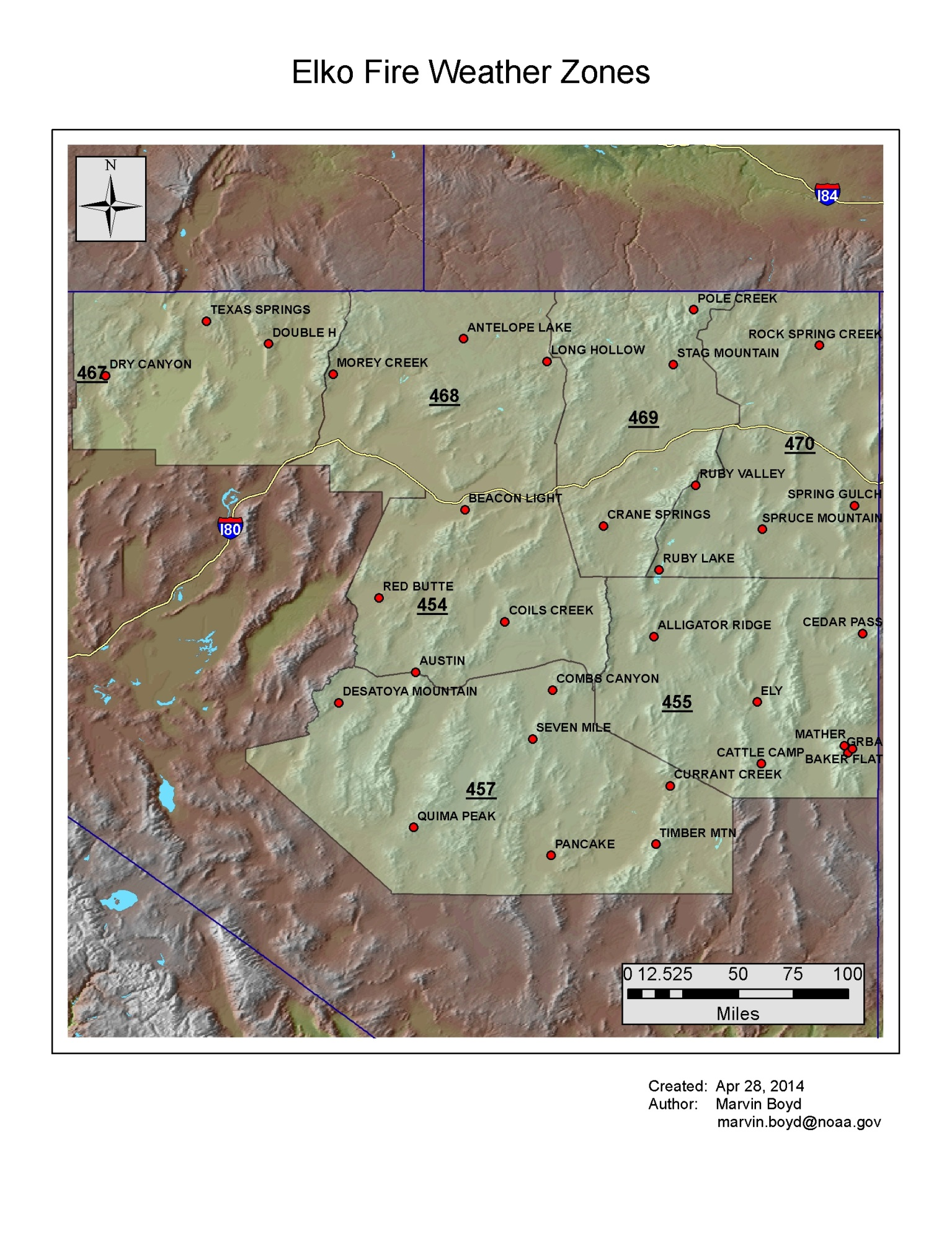
WFO Boise Fire Weather Zones
Elko
ELKO WEATHER FORECAST OFFICE
1. Changes for 2016 Season
See Main section of AOP for overall program changes
2. Hours of Operation
Depending on variables such as fuel parameters and customer need, seasonal Fire Weather Hours of Operation will be:
May 1st through October 31st: 0800-1600 PDT,
Forecast issued twice a day 0400-0700 and NLT 1530 PDT.
Staff meteorologists are available any time, 24 hours a day, 7 days a week. The fire weather desk is staffed from 0730 to 1530 PDT.
3. Staff and Contact Information
See Appendix A.
4. Fire Weather Services
A. Description of the Elko Fire Weather District:
- Great Basin Fire Weather Zones
- Zone 454: Northern Lander/Eureka Counties
- Zone 455: White Pine County
- Zone 457: Southern Lander/Eureka and Northern Nye Counties
- Zone 467: Central and Western Humboldt County
- Zone 468: Eastern Humboldt and Northwest Elko Counties
- Zone 469: Southwestern and Central Elko Counties
- Zone 470: Eastern Elko County
B. Basic Meteorological Services
Spot Forecasts: Requests for spot forecasts will be received via the Elko Fire Weather homepage found at: http://spot.nws.noaa.gov/cgi-bin/spot/spotmon?site=lkn
Follow-up phone calls are encouraged when requesting spot forecasts. In the event internet communications are not available, spot requests may be made by fax using the WS Form D-1 or by phone.
Forecast feedback is imperative to improving services. In many cases, the only way the forecaster will know what happened on a remote incident is through feedback from the fire community. You can phone in concerns or comments about forecasts to the forecaster on duty. Feedback may also be submitted in the remarks section on the next internet request, or by using the feedback option on the already processed internet-based spot forecast. Lastly, block 13 on the WS Form D-1 may be used in subsequent spot forecast requests. If forecast services or weather conditions significantly impact operations, please notify the WFO - Elko Forecaster on Duty at (775) 778-6720.
Fire Weather Significant Weather Advisories (SWA's): WFO Elko is issuing fire weather significant weather advisories (SWA's). These products replace the Fire Weather Short Term Forecasts (NOWCASTS) during 2015 and will continue to be issued during 2016. This product will provide forecast information for immediate fire weather concerns. At a minimum, dispatch will be notified when a fire weather significant weather advisory is issued.
C. Product Schedule
| Morning Fire weather forecast | 0400-0730 PDT |
| Fire Weather Significant Weather Advisories | Event-driven |
| Afternoon fire weather forecast | NLT 1530 PDT |
| NFDRS trends forecast | NLT 1545 PDT |
| Fire Weather Watch/Red Flag Warning | Event-driven |
| Spot Forecasts | On request |
D. Red Flag Events
Interagency Coordination: Before the issuance of a Red Flag Warning, there will be coordination with the affected agencies and neighboring NWS fire weather offices in order to assess fuel conditions and general fire danger.
Dissemination of Fire Weather Watches and Red Flag Warnings: Each issuance, update or cancellation of a Fire Weather Watch or Red Flag Warning will be relayed by a variety of methods, including NWS chat or phone, depending on the needs of the dispatch center. In addition there will be coordination or a call with the GACC.
Criteria for Red Flag Warnings and Fire Weather Watches:
Standard criteria have been developed for the Western Great Basin and can be found starting on GB 2016 AOP Page 4. However, local criteria specific to an area may be used in addition to the standard criteria.
Additional Decision Support Services:
Heads-up E-mails: NWS Elko will send out heads up e-mails to local fire partners ahead of expected weather events. To be added to the e-mail list, please contact Greg Barnhart (gregory.barnhart@noaa.gov), Clair Ketchum (clair.ketchum@noaa.gov), and/or Lynn Maple (lynn.maple@noaa.gov) or Michael Fitzsimmons (Michael.Fitzsimmons@noaa.gov).
Social Media: NWS Elko routinely makes updates to their pages on Facebook and Twitter. Although warnings are not disseminated through social media, updates will highlight upcoming critical fire weather events.
Facebook: http://www.facebook.com/US.NationalWeatherServiceElko.gov
Twitter: https://twitter.com/nwselko
Flagstaff
NWS FLAGSTAFF WEATHER FORECAST OFFICE
1. Changes for 2012 Season
See Main section of AOP for overall program changes.
2. Hours of Operation
Staff meteorologists will be on duty and available at any time, 24 hours a day, 7 days a week.
Forecast issued twice a day NLT 0730 and 1530 MST. (during the fire season)
Forecast issued once a day NLT 0730 MST. (outside of the fire season)
3. Staff and Contact Information
See Appendix B.
4. Fire Weather Services
A. Description of Flagstaff Fire Weather District within Eastern Great Basin:
- Arizona Fire Weather Zones
- Zone 104 – Kaibab Plateau, excluding the Kaibab NF
- Zone 105 – Marble and Glenn Canyons north of Colorado River
B. Basic Meteorological Services
Spot Forecasts: Requests for spot forecasts will be received via the Flagstaff Fire Weather homepage found at: http://spot.nws.noaa.gov/cgi-bin/spot/spotmon?site=fgz
C. Product Schedule
| Morning Fire weather forecast | By 0730 MST |
| Afternoon fire weather forecast | By 1530 MST |
| NFDRS point forecasts | By 1500 MST |
| Fire Weather Watch/Red Flag Warning | Event-driven |
| Spot Forecasts | On request |
D. Red Flag Events
Red Flag Criteria: All three of the following criteria must occur simultaneously for 3 hours.
A. Sustained 20-ft winds of 20 mph or greater and/or gusts of 35 mph or greater.
B. Relative humidity of 15 percent or lower.
C. A fire danger rating of high, very high or extreme.
Interagency Coordination: Before the issuance of a Red Flag Warning, there will be coordination with the affected agencies and neighboring NWS fire weather offices in order to assess fuel conditions and general fire danger.
Dissemination of Fire Weather Watches and Red Flag Warnings: Each issuance, update or cancellation of a Fire Weather Watch or Red Flag Warning will be relayed by telephone or fax to the dispatch office(s) and GACCs affected by the watch or warning.
Criteria for Red Flag Events: Standard criteria have been developed for the Great Basin and can be found starting on page 8. However, local criteria specific to an area may be used in addition to the standard criteria.
WFO Flagstaff Fire Weather Zones
Grand Junction
NWS GRAND JUNCTION WEATHER FORECAST OFFICE
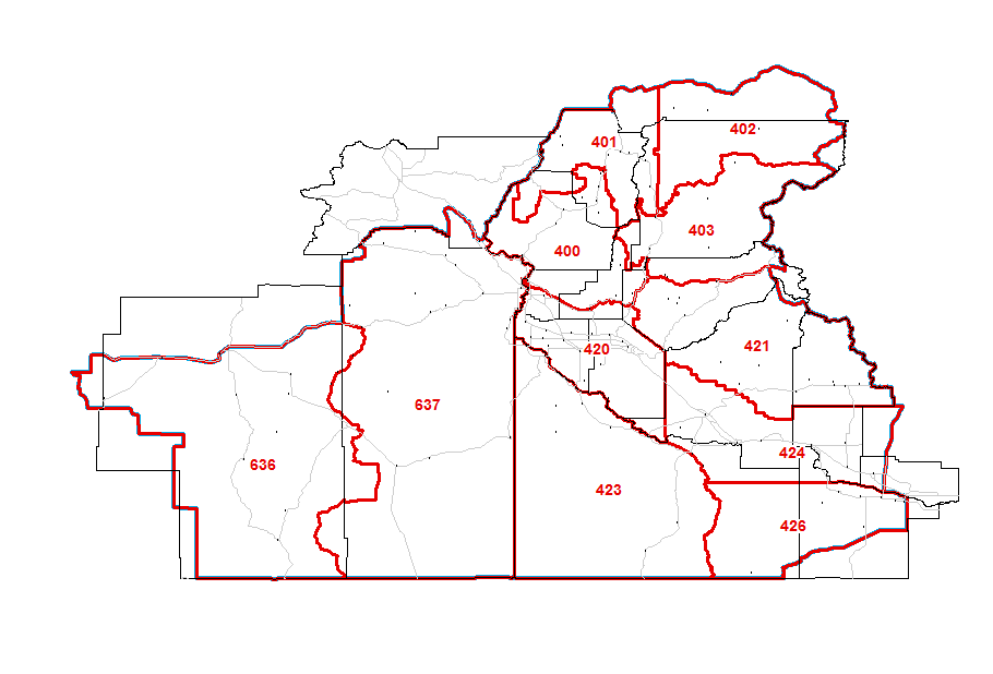
1. Changes for 2015 Season
In 2015, NWS Grand Junction no longer issue fire weather products for fire zones within NWS Salt Lake City’s County Warning Area (CWA) and NWS Salt Lake City will no longer issue fire weather products for fire zones within NWS Grand Junction’s CWA. See below and the attached map for details.
2. Hours of Operation
Staff fire weather meteorologists will be on duty and available at any time, 24 hours a day, 7 days a week, 365 day a year.3. Staff and Contact Information
See Appendix A.
4. Fire Weather Services
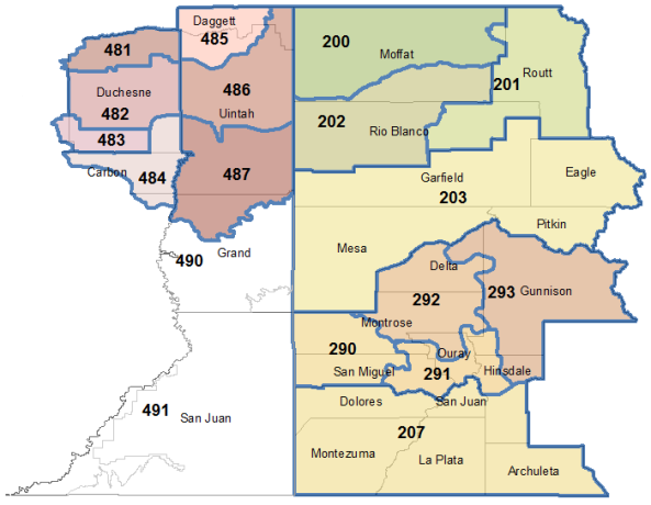
A. Description of Grand Junction Fire Weather District:
NWS Grand Junction CWA will issue all fire weather products for the following fire zones in eastern Utah: 485, 486, 487, 490 and 491. These products will include the Fire Weather Planning Forecast, Red Flag Warnings and Fire Weather Watches and spot forecasts.
Thus, WFO Grand Junction will issue the Fire Weather Planning Forecast (FWF) for the following zone group:
- Northeast Utah (eastern Uinta IFC Area)
- Zone 485 – Eastern Ashley National Forest
- Zone 486 – Eastern Uintah Basin
- Zone 487 – Book Cliffs
- Southeast Utah (eastern Moab IFC Area)
- Zone 490 – Colorado River Basin
- Zone 491 – Southeast Utah
Please see the map at the end of this section.
B. Spot Forecasts
The Grand Junction office prepares spot weather forecasts for prescribed burns and wildfires as requested for locations within the office’s County Warning Area, which includes spots requested within fire zones: 485, 486, 487, 490 and 491.
The primary means of requesting and disseminating spot forecasts is the NWS Spot Internet-based spot request and reply program, found at:
http://spot.nws.noaa.gov/cgi-bin/spot/spotmon?site=gjt
To ensure receipt by the fire weather forecaster, the requester should call the NWS after submitting each spot request. This call will serve two purposes: to confirm receipt of the request and provide an opportunity for the requester or the fire weather forecaster to ask questions. The forecaster will also be able to advise the requester of a possible delay in completing the forecast due to multiple spot requests. The fire weather forecaster will provide the same courtesy by calling the requesting agency after completing each spot forecast.
It is strongly recommended spot forecasts for prescribed burns NOT be requested between 1100 and 1500. This is a key fire weather and public forecast preparation period. Completion of spot forecasts for non-wildfires that are requested during this period will be delayed until after these key public and fire weather forecasts are completed.
At the beginning of a project, observations from a nearby RAWS site may be used for the INITIAL spot request. Unless the RAWS site is physically located on the burn project, all further spot requests must include weather observations taken by on-site personnel or other on-site instrumentation.
C. Product Schedule
| Morning Fire weather forecast | NLT 0800 MDT |
| Afternoon fire weather forecast | NLT 1530 MDT |
| NFDRS point forecasts | NLT 1545 MDT |
| Fire Weather Watch/Red Flag Warning | Event-driven |
| Spot Forecasts | On request |
D. Red Flag Events
Zone 485 – Eastern Ashley National Forest
Zone 486 – Eastern Uintah Basin
Zone 487 – Book Cliffs
Zone 490 – Colorado River Basin
Zone 491 – Southeast Utah
Interagency Coordination: Before the issuance of a Red Flag Warning, there will be coordination with the affected agencies and neighboring NWS fire weather offices to assess fuel conditions and general fire danger. Coordination of fuel conditions will be accomplished by accessing the GACC fuels page and from GACC/NWS conference calls. NWS Grand Junction will coordinate with the GACC meteorologist when considering a Fire Weather Watch or Red Flag Warning outside the normal fire season.
E. Smoke Management Forecast
A Graphical Utah Clearing Index Forecast is available in the fire weather sections of the Grand Junction and Salt Lake City web pages.
WFO Grand Junction also will include smoke management parameters (Mixing Height, Transport Wind, and Clearing Index) within the Fire Weather Planning Forecast
F. Incident Meteorologists (IMET)
The Grand Junction office has one or two certified IMETs available for dispatch to major forest fires and incidents. Dispatch for significant prescribed burn projects will only be possible when coordination with the fire weather program leader and WFO Meteorologist-in-Charge (MIC) is accomplished well in advance (i.e., months in advance) of the project and only when NWS manpower and resources permit.
WFO Grand Junction Fire Weather Zones
Las Vegas
NWS LAS VEGAS WEATHER FORECAST OFFICE
1. Changes for 2014 Season
The NWS Las Vegas office has no certified Incident Meteorologists as of the signing of this document. (See Main section of AOP for overall program changes.)
2. Hours of Operation
Staff meteorologists are on duty at WFO Las Vegas 24 hours a day throughout the year.
Scheduled dates and times for the Fire Weather Planning Forecast and NFDRS forecasts are:
5/1 through 10/31: Planning Forecast issued twice daily at 0700 and 1500 PDT.
NFDRS forecast issued by 1530 PDT.
Off season: Planning Forecast issued once daily at 0700 local time.
Depending on variables such as fuel parameters and customer need, seasonal Fire Weather dates may begin earlier in the season or continued later in the season.
3. Staff and Contact Information
See Appendix B.
4. Fire Weather Services
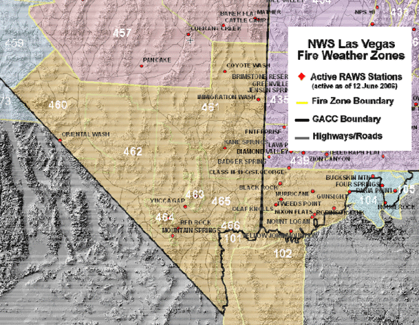
A. Description of Las Vegas Fire Weather District within the Great Basin:
- Arizona Fire Weather Zones in the Great Basin:
- Northern Zone 101 – Lake Mead
- Northern Zone 102 – Northwest Plateau (Arizona Strip) and Northwest Deserts
- Zone 460 – Central Nevada Dispatch Southern Deserts – Esmeralda and parts of Central Nye County
- Zone 461 – Lincoln County - Ely Dispatch
- Zone 462 – Nye County Deserts - LV Dispatch
- Zone 463 – Sheep Range
- Zone 464 – Spring Mountains
- Zone 465 – Clark and SW Lincoln County Deserts
- Zone 466 – Lake Mead and Colorado River - LV Dispatch
See map at end of this section.
B. Basic Meteorological Servcies
Spot Forecasts: Requests for spot forecasts will be received via the Las Vegas Fire Weather homepage found at: http://spot.nws.noaa.gov/cgi-bin/spot/spotmon?site=vef
Follow-up phone calls are encouraged when requesting spot forecasts. In the event internet communications are not available, spot requests may be made by fax using the WS Form D-1 or by phone.
Forecast feedback is imperative to improving services. In many cases, the only way the forecaster will know what happened on a remote incident is through feedback from the fire community. You can phone in concerns or comments about forecasts to the forecaster on duty. Feedback may also be submitted in the remarks section on the next internet request, or by using the feedback option on the already processed internet-based spot forecast. Lastly, block 13 on the WS Form D-1 may be used in subsequent spot forecast requests. If forecast services or weather conditions significantly impact operations, please notify the Fire Weather Program Leader, via phone or email. See Appendix A for contact information.
C. Product Schedule
| Morning Fire weather forecast | NLT 0700 PST (0400-0730 Pacific Time) |
| Afternoon fire weather forecast | NLT 1530 PST |
| NFDRS point forecasts | NLT 1530 PST |
| Fire Weather Watch/Red Flag Warning | Event-driven |
| Spot Forecasts | On request |
D. Red Flag Events
Interagency Coordination: Before the issuance of a Red Flag Warning, there will be coordination with the affected agencies and neighboring NWS fire weather offices to assess fuel conditions and fire danger.
Dissemination of Fire Weather Watches and Red Flag Warnings: Each issuance, update or cancellation of a Fire Weather Watch or Red Flag Warning falling between normal narrative forecast issuance times will be relayed by telephone to the dispatch office(s) and GACC affected by the watch/warning.
Criteria for Red Flag Warnings and Fire Weather Watches:
Fuels are critical and sustained winds greater than or equal to 20 mph or gusts greater than or equal to 35 mph for 3+ hours and relative humidity less than or equal to 15% OR Dry Thunderstorms with areal coverage of widely scattered or greater (>15%) in a fire weather zone. (Standard criteria have been developed for the Western Great Basin and can be found starting on page 8. However, local criteria specific to an area may be used in addition to the standard criteria. For Las Vegas, red flag criteria will include sustained winds greater than or equal to 20 mph and/or gusts greater than or equal to 35 mph for 3 or more hours in a given period.)
E. Smoke Management Forecast
Mixing Height, Transport Winds and Ventilation Category are provided for each zone in the fire weather planning forecast. That information is provided for a single point in each zone with that point noted at the end of the fire weather planning forecast.
F. Incident Meteorologists (IMETs)
As of the signing of this document the Las Vegas office had no certified IMETs available for dispatch to major fires and incidents. There is one IMET Trainee.
G. Additional Decision Support Services
Heads-up E-mails: NWS Las Vegas will send out heads up e-mails to local fire partners ahead of expected weather events. To be added to the e-mail list, please contact Jim Harrison (jim.harrison@noaa.gov) or Dan Berc (daniel.berc@noaa.gov).
Social Media: NWS Las Vegas routinely makes updates to their pages on Facebook and Twitter. Although warnings are not disseminated through social media, updates will highlight upcoming critical fire weather events.
Facebook: http://www.facebook.com/US.NationalWeatherServiceLasVegas.gov
Twitter: https://twitter.com/nwsvegas/
WFO Las Vegas Fire Weather Zones

Pocatello
NWS POCATELLO WEATHER FORECAST OFFICE
1. Changes for 2014 Season
The National Weather Service Office in Pocatello, Idaho will change the criteria for Red Flag Warnings for thunderstorm activity in Southeast Idaho to 25 percent of areal coverage. There will not be a distinction between “wet” and “dry” thunderstorms; i.e. > 0.10 inch rain. See Main section of AOP for overall program changes.
2. Hours of Operation
Staff meteorologists are on duty at WFO Pocatello 24 hours a day throughout the year. Concerns about current or developing weather conditions may be discussed anytime. Scheduled dates for issuance of the Fire Weather Planning Forecast and NFDRS forecasts are:
Second Monday in May: Forecast issued once a day NLT 0700 MDT.
Second Monday in June through Last Friday in October: Forecast issued twice a day NLT 0700 and 1530 MDT.
Depending on variables such as fuel parameters and customer need, seasonal Fire Weather dates may begin earlier in the season or continue later in the season.
3. Staff and Contact Information
See Appendix B.
4. Fire Weather Services
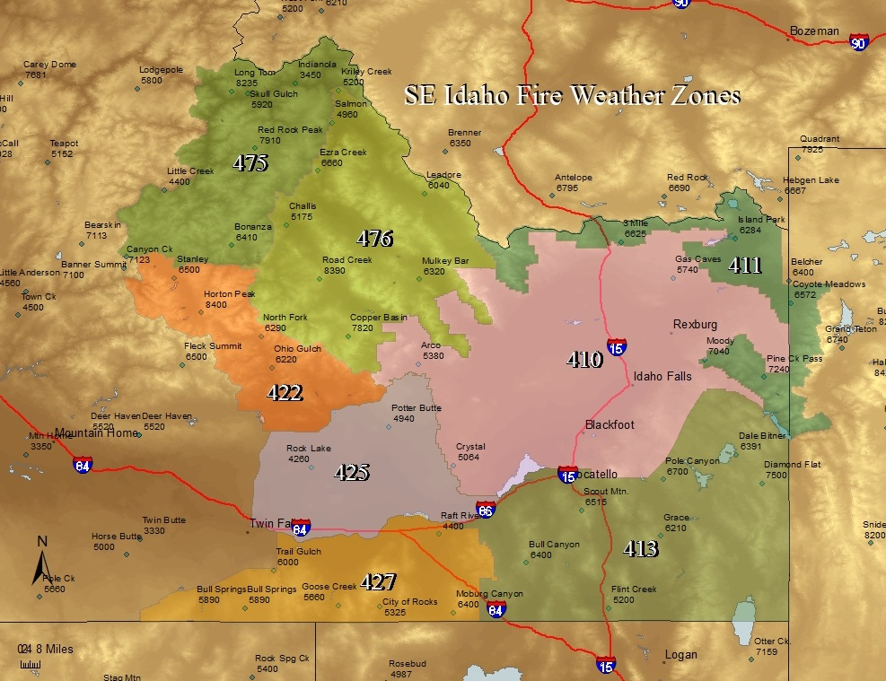
A. Description of Pocatello Fire Weather District:
- East Central Idaho Mountains
- Zone 475: East Salmon River Mountains/Salmon N, includes western half of Salmon-Challis NF and portions of Idaho Falls BLM District.
- Zone 476: Lemhi and Lost River Range/Challis NF, includes eastern half of Salmon-Challis NF and portions of the Idaho Falls BLM District.
- Zone 422: Sawtooth Range/Northern Sawtooth NF: includes the Sawtooth NRA.
- Upper Snake River Plain
- Zone 425: Middle Snake River Valley/Twin Falls BLM: Includes Twin Falls BLM District north of the Snake River, Minidoka NWR, and Craters of The Moon NM.
- Zone 410: Upper Snake River Valley/Idaho Falls BLM, includes Northeast portion of Idaho Falls BLM District, Camas NWR, Idaho State Land Department – Cotton Protective District, southeastern Birch Creek and Little Lost River Valleys.
- Upper Snake Highlands
- Zone 411: Centennial Mountains and Snake River Range/Targhee NF, Caribou-Targhee NF north of Palisades Reservoir excluding eastern slopes of Lemhi Mountain Range.
- Southeast Idaho Highlands
- Zone 427: Goose Creek and Raft River Valley/Southern Sawtooth NF: Includes the southern portion of the Sawtooth NF, and portions of the Twin Falls BLM District south of the Snake River.
- Zone 413: Caribou Range/Caribou NF, Caribou-Targhee NF south of Palisades Reservoir, portions of Idaho Falls BLM District east of Snake River, Grays Lake NWR, and Bear Lake NWR.
B. Basic Meteorological Services
Spot Forecasts: Requests for spot forecasts will be received via the Boise Fire Weather homepage found at: http://spot.nws.noaa.gov/cgi-bin/spot/spotmon?site=pih
C. Product Schedule
| Morning Fire weather forecast | By 0700 MDT |
| Internet Briefing | At 0900 MDT |
|
|
| Afternoon fire weather forecast | NLT 1530 MDT |
| NFDRS point forecasts | NLT 1545 MDT |
| Fire Weather Watch/Red Flag Warning | Event-driven |
| Spot Forecasts | On request |
D. Red Flag Events
Interagency Coordination: Before the issuance of a Red Flag Warning, there will be coordination with the affected agencies in order to assess fuel conditions and general fire danger. The Critical Fuels Status page maintained by Predictive Services serves as a primary source of fuels information. The 7-Day Fuel Dryness product issued by Predictive Services will be used in parallel with the Critical Fuels Status page this year for comparison.
Dissemination of Fire Weather Watches and Red Flag Warnings: Each issuance, update or early cancellation of a Fire Weather Watch or Red Flag Warning will be relayed by telephone to the dispatch office(s) and GACC affected by the watch/warning. For Red Flag Warnings that run their stated valid time and expire between 600 pm and 600 am local time, a single notification call will be made to Eastern Great Basin Coordination Center Predictive Services who in turn will notify the appropriate on-call number.
Criteria for Red Flag Warnings and Fire Weather Watches:
Fire Weather Watches and Red Flag Warnings, are issued for conditions of very high or extreme fire danger (as determined by land management agencies) and dry fuels, in combination with one of the following:
- Widely scattered or greater (> 25% of aerial coverage) thunderstorm activity, even if precipitation is expected to exceed 0.10 inch of rain.
- Winds gusts for any three or more hours > 25 mph for Southeast Idaho Mountains, > 30 mph for the Snake River Plain and relative humidity is < 15 percent.
- In the judgment of the forecaster, weather conditions will create a critical fire control situation. These conditions may include strong microburst winds, passage of a cold front or a strong wind shift.
WFO Pocatello Fire Weather Zones
Reno
NWS Reno WEATHER FORECAST OFFICE
1. Changes for 2014 Season
See Main section of AOP for overall program changes.
2. Hours of Operation
Depending on variables such as fuel parameters and customer need, seasonal Fire Weather Hours of Operation will be::
5/1 through 10/31: 0800-1600 PDT.
Forecast issued twice a day 0400-0730 and NLT 1530 PDT.
Staff meteorologists are on duty and available at any time, 24 hours a day, 7 days a week.
3. Staff and Contact Information
See Appendix B.
4. Fire Weather Services
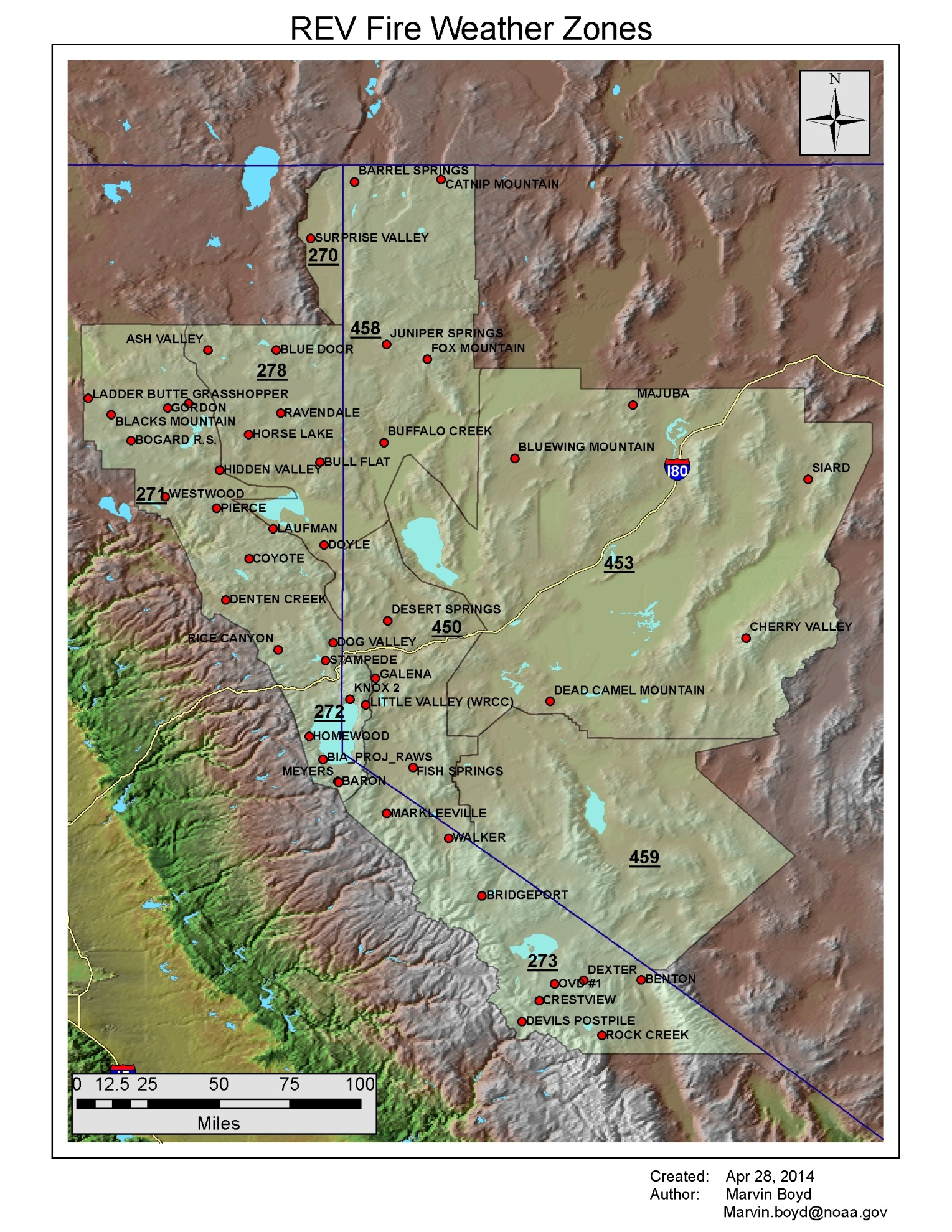
A. Description of the Reno Fire Weather District within the Great Basin:
- Arizona Fire Weather Zones in the Great Basin:
- Zone 450 – Sierra Front
- Zone 453 – West Central Nevada Basin and Range
- Zone 458 – Northern Washoe County
- Zone 459 – Mineral and Southern Lyon Counties
- Zone 272 – Lake Tahoe Basin and Carson Range
- Zone 273 – Mono and Eastern Alpine Counties
See map at end of this section.
B. Basic Meteorological Servcies
Spot Forecasts: Requests for spot forecasts will be received via the Reno Fire Weather homepage found at: http://spot.nws.noaa.gov/cgi-bin/spot/spotmon?site=rev
Follow-up phone calls are encouraged when requesting spot forecasts. In the event internet communications are not available, spot requests may be made by fax using the WS Form D-1 or by phone.
Forecast feedback is imperative to improving services. In many cases, the only way the forecaster will know what happened on a remote incident is through feedback from the fire community. You can phone in concerns or comments about forecasts to the forecaster on duty. Feedback may also be submitted in the remarks section on the next internet request, or by using the feedback option on the already processed internet-based spot forecast. Lastly, block 13 on the WS Form D-1 may be used in subsequent spot forecast requests. If forecast services or weather conditions significantly impact operations, please notify the Fire Weather Program Leader, via phone or email. See Appendix A for contact information.
C. Product Schedule
| Morning Fire weather forecast | 0400-0730 PDT |
| Afternoon fire weather forecast | NLT 1530 PST |
| NFDRS trends forecasts | NLT 1545 PST |
| Fire Weather Watch/Red Flag Warning | Event-driven |
| Spot Forecasts | On request |
D. Red Flag Events
Interagency Coordination: Before the issuance of a Red Flag Warning, there will be coordination with the affected agencies and neighboring NWS fire weather offices to assess fuel conditions and general fire danger.
Dissemination of Fire Weather Watches and Red Flag Warnings: Each issuance, update or cancellation of a Fire Weather Watch or Red Flag Warning falling between normal narrative forecast issuance times will be relayed by telephone to the dispatch office(s) and GACC affected by the watch/warning.
Local Criteria for Red Flag Warnings and Fire Weather Watches:
Standard criteria have been developed for the Western Great Basin and can be found starting on page 4. However, local criteria specific to an area may be used in addition to the standard criteria.
Lake Tahoe Basin (Fire Zone 272): Wind gusts >30mph with Relative Humidity less than 20%, conditions must present for 3 hours or more.
When fuel moistures become extreme, Red Flag Warnings will be issued for Gusts > 30 mph regardless of humidity. Fuel Moistures will be closely coordinated with the Lake Tahoe Basin Management Unit and other partner agencies to determine when they transition from critical to extreme.
E. Briefings
Reno Fire Weather Conference Calls: These will be conducted through the fire season on Mondays and Fridays at 0945. Briefings will be held daily during critical fire weather patterns or during periods of numerous ongoing wildfires. Calls will consist of an overview of the warnings and watches throughout the region, a satellite/radar overview, along with detailed analysis of critical fire weather parameters such as winds, humidity, and lightning.
G. Additional Decision Support Services
Fire Partner E-mails: NWS Reno will send out heads up e-mails to local fire partners ahead of expected weather events. To be added to the e-mail list, please contact Alex Hoon (alexander.hoon@noaa.gov) or Edan Lindaman (edan.lindaman@noaa.gov).
Social Media: NWS Reno routinely makes updates to their pages on Facebook and Twitter. Although warnings are not disseminated through social media, updates will highlight upcoming critical fire weather events.
Facebook: http://www.facebook.com/US.NationalWeatherService.Reno.gov
Twitter: https://twitter.com/nwsreno/
Riverton
NWS RIVERTON WEATHER FORECAST OFFICE
1. Changes for 2014 Season
None
2. Hours of Operation
Depending on variables such as fuel parameters and customer need, seasonal Fire Weather Hours of Operation will be:
5/1 through 10/31: Forecast issued twice a day NLT 0700 and 1500 MDT.
Staff meteorologists will be on duty and available at any time, 24 hours a day, 7 days a week.
3. Staff and Contact Information
See Appendix B.
4. Fire Weather Services
A. Description of Riverton Fire Weather District:
- Great Basin Fire Weather zones
- Zone 414: Bridger-Teton NF and surrounding mountains in Lincoln County and Sublette County west of Highway 189/191.
- Zone 415: Bridger-Teton NF in extreme western Fremont County and southwest Park County, Teton County excluding the Targhee NF and extreme northwest Sublette County.
- Zone 416: Bridger-Teton NF and surrounding mountains in Sublette County east of Highway 189/191 and a small portion of Fremont County west of South Pass.
See map at end of section.
B. Basic Meteorological Services
Spot Forecasts: Requests for spot forecasts will be received via the Boise Fire Weather homepage found at: http://spot.nws.noaa.gov/cgi-bin/spot/spotmon?site=riw
C. Product Schedule
| Morning Fire weather forecast | By 0700 MDT |
| Afternoon fire weather forecast | NLT 1500 MDT |
| NFDRS point forecasts | NLT 1545 MDT |
| Fire Weather Watch/Red Flag Warning | Event-driven |
| Spot Forecasts | On request |
D. Red Flag Events
Interagency Coordination: Before the issuance of a Red Flag Warning, there will be coordination with the affected agencies and neighboring NWS fire weather offices in order to assess fuel conditions and general fire danger.
Dissemination of Fire Weather Watches and Red Flag Warnings: Each issuance, update or cancellation of a Fire Weather Watch or Red Flag Warning will be relayed by telephone to the dispatch office(s) and GACC affected by the watch/warning.
Criteria for Red Flag Warnings and Fire Weather Watches:
Standard criteria have been developed for the Great Basin and can be found starting on page 8. However, local criteria specific to an area may be used in addition to the standard criteria. For Riverton, Red Flag Criteria will be Wind Gusts ≥ 25 mph for any 3+ hours and Relative Humidity of ≤15%, or for Dry Thunderstorms with an areal coverage of widely scattered or great (≥15%) in a Fire Weather Zone or for widely scattered wet and dry thunderstorms (LAL of 3 or greater) over exceptionally dry fuels (as determined by our partners).
WFO Riverton Fire Weather Zones
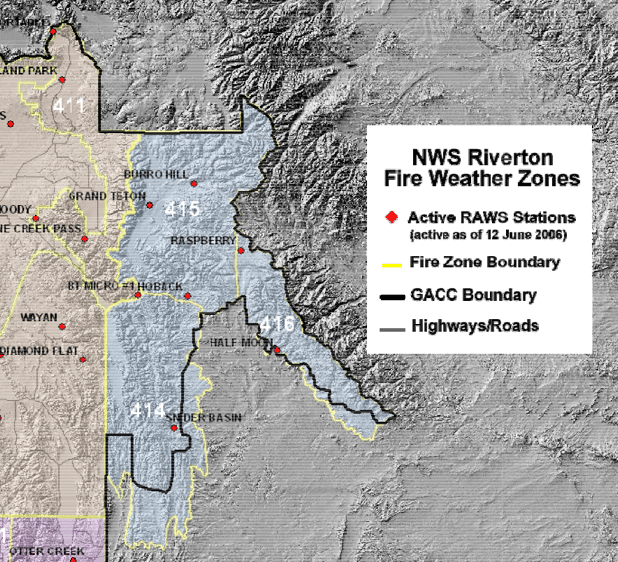
Salt Lake City
NWS SALT LAKE CITY WEATHER FORECAST OFFICE
1. Changes for 2014 Season
The National Weather Service Office in Salt Lake City, Utah will produce an experimental Forecast Matrix for each forecast zone beginning in June. This will be accessible via the top row of forecast options of the Fire Weather Page.
2. Hours of Operation
4/28 through 10/31: Designated Fire Weather Desk 0700-1600 MDT
Depending on variables such as fuel parameters and customer need, seasonal fire weather hours of operation are subject to change.
Fire Weather Planning Forecasts will be issued twice daily, NLT 0500 and 1500 MDT.
Staff meteorologists will be on duty and available at any time, 24 hours a day, 7 days a week.
3. Staff and Contact Information
See Appendix B.
4. Backup Operations
On occasion, SLC may be unable to perform normal operations. In this event, WFO Grand Junction, CO (GJT) will serve as SLC’s primary backup and WFO Pocatello, ID (PIH) will serve as secondary backup.
5. Fire Weather Services
A. Description of Salt Lake City Fire Weather District:
The WFO SLC will produce SPOT and NFDRS forecasts for their CWA which includes the following zones:
Zone 478, “Salt Lake Desert”. This zone includes the Great Salt Lake Desert and the Wasatch Front from Nephi to the Idaho border.
Zone 479, “Wasatch Mountains”. This zone includes the Wasatch Mountains, Wasatch Mountain Valleys, the Cache Valley and the Bear River Valley along the Wyoming border.
Zone 480, “Uinta Mountains”. This zone includes the north slopes of the Uinta Mountains in Summit County.
Zone 481, “Western Ashley National Forest”. This zone includes the south slopes of the Uinta Mountains in Duchesne County.
Zone 482, “Western Uintah Basin”. This zone includes the western portion of the Uintah Basin in Duchesne County.
Zone 483, “Southern Ashley National Forest”. This zone includes the Ashley National Forest in extreme eastern portion of Wasatch County and southwest Duchesne County.
Zone 484, “Tavaputs Plateau”. This zone includes the Tavaputs Plateau and the western portion of the Book Cliffs.
Zone 488, “Manti National Forest”. This zone includes the northern portion of the central mountains, otherwise known as the Wasatch Plateau. This area is mostly contained within Sanpete County.
Zone 489, “San Rafael Swell”. This zone includes Castle Country and the San Rafael Swell.
Zone 492, ”Central Utah West Desert”. This zone includes the west desert of Juab and Millard Counties, as well as the northern half of the Sevier Valley.
Zone 493, “Central Utah Mountains”. This mountainous zone lies mainly within the counties of Sevier and Piute, as well as the western portion of Wayne County.
Zone 494, “Henry Mountains”. This zone includes the Henry Mountains, northwest portion of Canyonlands, and the eastern portion of Capitol Reef National Park.
Zone 495, “Color Country West Desert”. This zone includes most of the lower elevations of Iron and Beaver Counties.
Zone 496, “Color Country Mountains”. This zone includes the higher terrain of southwest Utah from the Pine Valley Mountains, eastward to Boulder Mountain, and the western portion of Capitol Reef National Park.
Zone 497, “Mojave Desert”. This zone includes the northern portion of the Arizona Strip, within Washington County, Utah.
Zone 498, “Grand Staircase”. This zone includes the Grand Staircase-Escalante National Monument in Kane and southern Garfield Counties, as well as the Lake Powell region.
The WFO SLC will produce Red Flag Warning (RFW) and Fire Weather Planning Forecasts (FWF) for the following zones:
Northern Utah (Northern Utah IFC)
Zone 478 – Salt Lake Desert
Zone 479 – Wasatch Mountains
Zone 480 – Uinta Mountains
East Central Utah (Moab IFC)
Zone 488 – Manti National Forest
Zone 489 – San Rafael Swell
Zone 490 – Colorado River Basin - This zone contains the low elevations surrounding the Colorado River between the Colorado-Utah border and Moab.
Zone 491 – Southeast Utah - This zone includes all of southeast Utah from Lake Powell eastward to the Colorado border, and north to about the latitude of Moab.
West Central Utah (Richfield IFC)
Zone 492 – Central Utah West Desert
Zone 493 – Central Utah Mountains
Zone 494 – Henry Mountains
Southwest Utah (Cedar City IFC)
Zone 495 – Color Country West Desert
Zone 496 – Color Country Mountains
Zone 497 – Mojave Desert
Zone 498 – Grand Staircase
See map at the end of section.
B. Basic Meteorological Services
The following services are provided to Land Management Agencies in the state of Utah:
GoToMeeting: During fire season, GoToMeeting Web-based briefings will be hosted for event-driven cases only. These event-driven meetings will be scheduled via e-mail with a one day advance notice when possible. These verbal and visual briefings will include a general discussion of weather conditions and forecasts for the current day, as well as brief discussion of the extended period. A preset group of images consisting of model data, satellite and radar loops, GFE forecasts and/or observations utilizing AWIPS graphics, and other items of interest will be addressed for the forecast period.
The GoToMeeting is intended to be less than 10 minutes, but may be longer during complex scenarios.
YouTube Briefings: During the fire season (beginning the first Monday in June unless dictated by fire weather conditions developing in May) every Monday at 1100 MDT, and prior to significant fire weather events impacting the Utah region, a fire weather briefing will be recorded and posted on YouTube. Notification that a YouTube presentation is available will be accomplished via e-mail. The briefings will also be highlighted on WFO SLC Web pages. The presentations will be updated as needed, and remain on YouTube for reference.
Emergency Fire Weather Briefings: During emergency situations when a Site-specific (Spot) Forecast will take too long to initiate, please call for weather information. Ask to speak with the Fire Weather Forecaster on duty. If a fire weather forecaster is not in the office, ask to speak with the Lead Forecaster.
Fire Weather Planning Forecasts (FWF): Disseminated via WIMS and our Fire Weather Web page twice a day from 4/28 through 10/31. Issuance times are NLT 0500 MDT and 1500 MDT. Times will vary according to the current weather situation/Site-specific (Spot) Forecast workload, though every effort will be made to make the forecast available as soon as possible. The GACC Predictive Services Meteorologist or the Coordinator on Duty (COD) outside of the GACC operational hours will be notified of any updates.
Smoke Management Forecasts (SMF): Smoke Management Forecasts (SMF): Disseminated once a day from 5/5 through 10/31. Issuance times will usually be from 1100-1200 MDT depending on Site-specific (Spot) Forecast workload. Outside the normal burning season, the Weather Activity Planner, graphical Clearing Index, and/or the Utah Clearing Index may be used.
Site-specific (Spot) Forecasts:
Please utilize the web-based system on our homepage to request Site-specific (Spot) Forecasts, found at:
http://spot.nws.noaa.gov/cgi-bin/spot/spotmon?site=slc
Fire Weather Watches/Red Flag Warnings:
Dry Lightning or Low RH and Strong Winds: Normally issued via our Fire Weather Web page and WIMS with the routine forecast package (NLT 0500 MDT or 1500 MDT) and as a separate product. Coordination calls are made as needed to EGB GACC and/or local dispatch centers to verify fuel conditions. FMOs, FBAs, and Burn Bosses should make every effort to call the Fire Weather Forecaster on duty whenever there is any concern about critically dry fuels and/or severe fire behavior.
Fire Weather Watches and Red Flag Warnings for these events will be based on the standard criteria set forth in this document, beginning on NWS Roles 1. Basic Services – B. Red Flag Warnings section.
Fuel Dryness and Lightning Probability Information:
Experimental Fuel Dryness and Lightning Probability Information will continue in 2014. (See EGB GACC Roles - Operational Support and Predictive Services).
Gridded Forecast Products: The Point Forecast Matrix (PFM) is available and accessible via a radio button along the top of the Fire Weather Web page. This product is a tabular forecast. This seven day forecast is detailed for the first 72 hours, while the forecast information for days 4 through 7 contains fewer parameters and is of less temporal resolution.
Any suggestions on how to improve any forecast services are very welcome; please email your suggestions or call the Fire Weather Program Leader, Mark Struthwolf.
C. Product Schedule
| Morning Fire weather forecast | By 0500 MDT |
| Afternoon fire weather forecast | By 1500 MDT |
| Smoke Management Forecast | By 1200 MDT |
| NFDRS point forecasts | By 1545 MDT |
| Fire Weather Watch/Red Flag Warning | Event-driven |
| Spot Forecasts | On request |
WFO Salt Lake City Fire Weather Zones
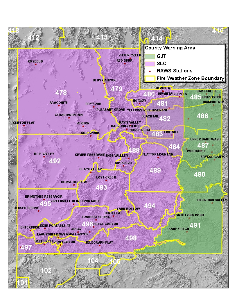
To obtain a copy of the 2014 GBGACC/NWS Directory, contact Great Basin Predictive Services.
Print AOP
Check the sections you wish to print, then click the PRINT button.
Introduction/Changes for 2014NWS Roles
GBGACC Roles
Joint Roles
Dates/Signatures
Appendix A - WFOs