
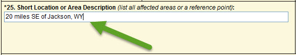
Block 25. Short location or Area Description 
A general descriptive location of the incident (does not need to be from the incident point of origin). This should be the number of miles from an identifiable town (e.g., “20 miles SE of Jackson, WY”).
This information is important for readers unfamiliar with the area to be able to quickly identify the general location of the incident on a map.
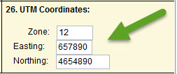
Block 26. Universal Transverse Mercator (UTM) Coordinates
Enter the UTM at the incident’s point of origin. Confirm the UTM coordinates entered are expressed in NAD83 data format.
Block 27. Geospatial Data
If geospatial data is available for the incident, provide the following information:
- A general description of the data (a perimeter, a point, area of impact, radius, and so forth)
- Indicate the data format (e.shp, .kml, .kmz)
- Include a link or access to the information if it is online or an FTP site
information.