Welcome to the Northwest Coordination Center
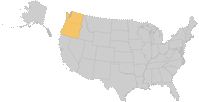
Northwest Fire Locations
NWCC Public Information Blog
www.nwccinfo.blogspot.com
Fire Map Load Time
Due to high user traffic, the large fire map may load slower than normal and will be briefly unavailable during morning updates.
Fire Perimeter
To view the fire's current perimeter, zoom in on the flame icon.
|
||||
 Active
  Complex
  Contained
The Northwest Fire Location map displays active fire incidents within Oregon and Washington.
A Large Fire, as defined by the National Wildland Coordinating Group, is any wildland fire in timber 100 acres or greater and 300 acres or greater in grasslands/rangelands or has an Incident Management Team assigned to it.
Please note: the points displayed on the map above indicate each fire's starting location and provide general references ONLY. Fire information is updated as it is received. However, gaps may exist in the daily updates submitted to NWCC, and the map above may not reflect the most current fire situation.
Fire points and perimeters are collected in the field by a variety of means, including infrared flights, and using GIS and GPS technology. Since data is not received for all fires, you may not be able to view perimeters of every fire.
-
Large Fire Information Summary
Detailed information for each fire; including the lead agency, description of location, number of threatened structures, cause, current conditions, etc.