
Southern California GACC Fire Weather Briefing
Last Modified: October 27, 2010
CONDITIONS PAST 24 HOURS TO CURRENT...
1. Current Red Flag Warnings and Fire Weather Watches from NWS (Updated Hourly)
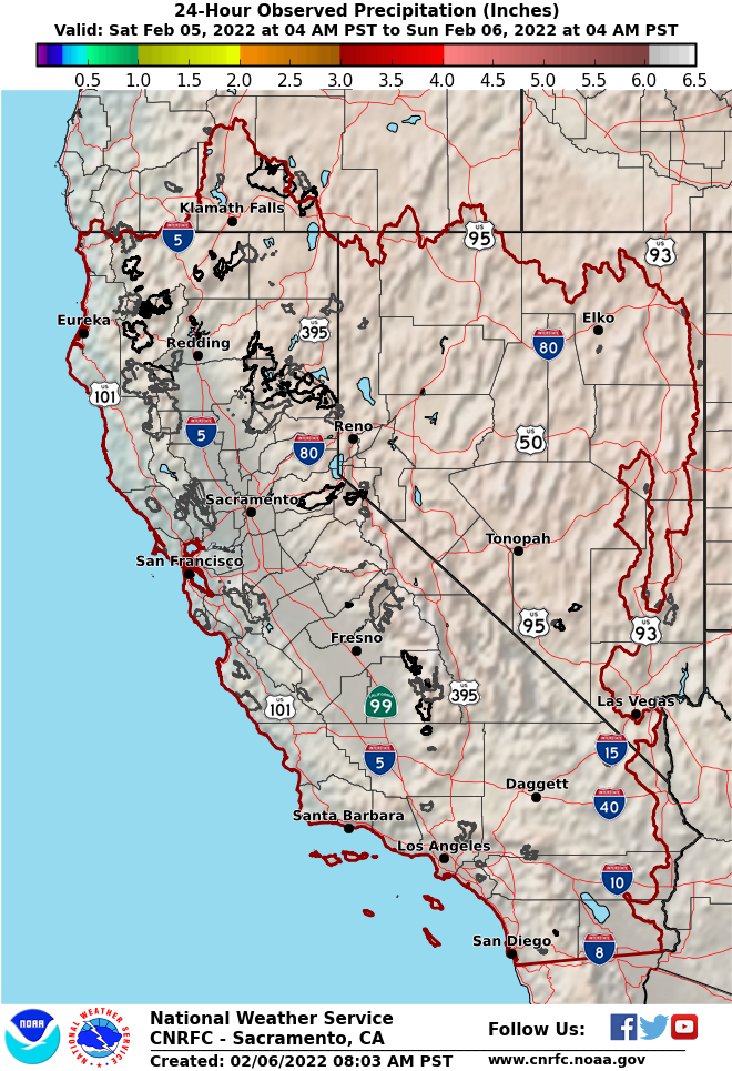
2a. Past 24 Hours (5 a.m. to 5 a.m.) Total Precipitation (California-Nevada River Forecast Center)

2b. Radar Estimated Total Precipitation Past 24 hours 5 a.m. to 5 a.m. (Double click on area of interest twice, then double click twice again in area of interest to zoom in)

3. 0500 PDT Observed Haines Index (Red & Orange indicate dry and Possibly Unstable Conditions)
 |
 |
(Click satellite image to loop or 500mb chart to enlarge)
4. Current National Water Vapor Image (Blue/Purple is mid/upper level moisture, dark red is dry). |
5. 500mb (18,000 ft MSL) Heights & Winds |
|
|
|
6. Current 1-Hour National Radar Composite Loop |
|
|
 |
(Click satellite image to loop or surface chart to enlarge
| 7. Current West Visible Satellite | 8. Current West U.S. Surface Plot (red=temperatures and green=dewpoint, wind barbs - each long flag = 10 kts and 5 kts for short flag.) |
CURRENT CONDITIONS...
 |
 |
9. Current Temperature | 10. Current Dew Point Temperature |
 |
 |
11. Current Wind Speed | 12. Current Surface Pressure |
 |
 |
13. 24-Hour Temperature Change | 14. Moisture Convergence |
|
Day 1 - SPC National Fire Weather Outlook |

|
Day 2 - SPC National Fire Weather Outlook |

15. National Fire Weather Outlook from NOAA/NWS Storm Prediction Center - Large scale weather features with expected Critical Fire Weather Areas outlined in red. (Click here for accompanying text discussion and Day1 and Day 2 outlook) and and click here for the 3 to 8 day Extended Outlook This is for general, broad-scale planning and guidance purposes only and may not be entirely consistent with the more detailed information provided by the local NWS offices.
FORECAST CONDITIONS (Significant Trends Next 7+ Days)...

16. Forecast Total Rainfall Over Next 5 Days (Atmospheric Model Modified by a Forecaster)
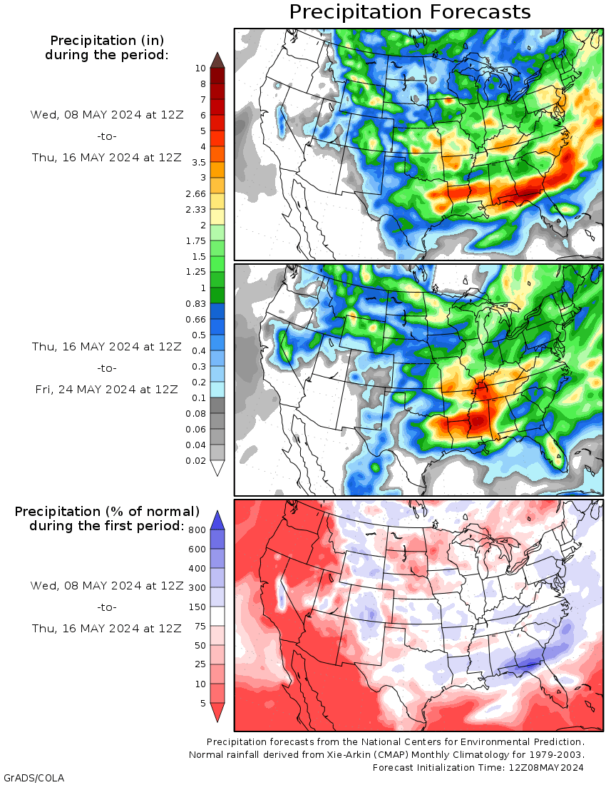
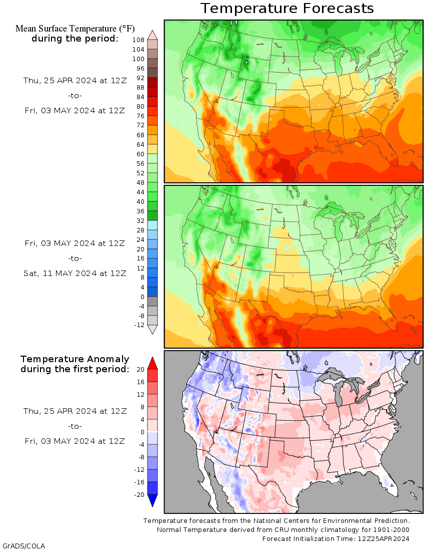
17. 15-Day Precipitation and Temperature Forecasts and Anomalies (Pure Atmospheric Model Output)
18. Link to latest 7-Day Significant Fire Potential Outlook from Southern California Predictive Services

