INCIDENT INFORMATION
 
PREDICTIVE SERVICES
  Intelligence
  Weather
  Fuels/Fire Danger
  Outlooks
   
LOGISTICS / DISPATCH
  Aviation
  Crews
   
ADMINISTRATIVE
  California Wildfire Coordination Group
  Policy and Reports
  Incident Business Management
  Safety Management
  Software Applications
  Training
   
RELATED LINKS
[graphic] Color Curve
 

PREDICTIVE SERVICE AREA CHARTS

Predictive Services Logo erc chart

Dead Fuel Moisture

This is the moisture content of dead organic fuels, expressed as a percentage of the oven dry weight of the sample, that is controlled entirely by exposure to environmental conditions.

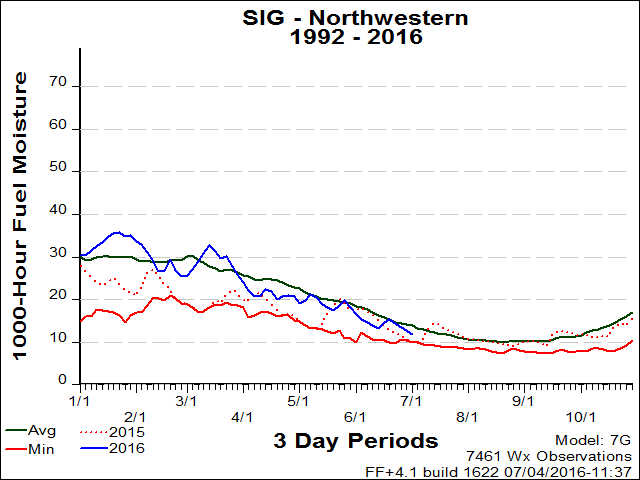
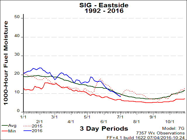
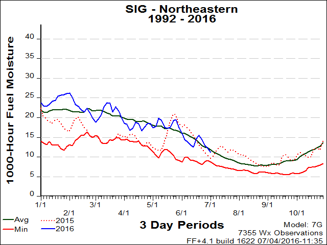
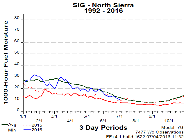
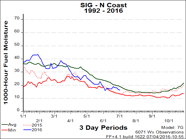
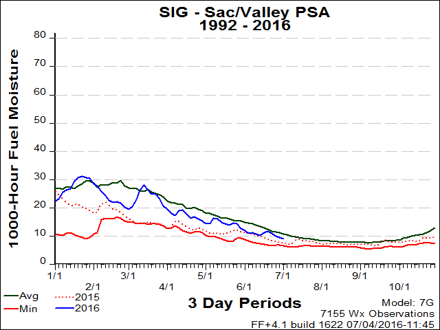
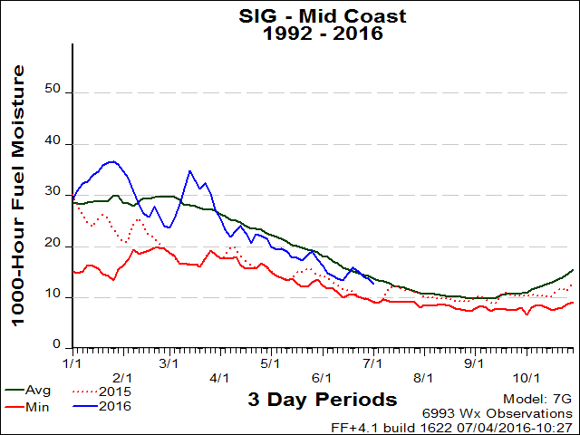
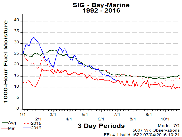
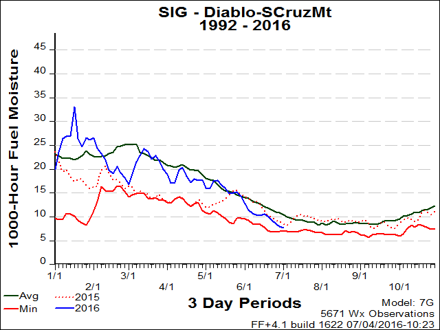
Thousand Hour Dead Fuel Moisture (1000hr)

1000-Hour dead fuel moisture levels are computed from a 7-day average boundary condition composed of day length, hours of rain, and daily temperature/humidity ranges. Fuel sizes range from 3 to 6 inches in diameter.

Northwestern Mountains » Eastside » Northeastern Mountains » Northern Sierra » North Coast » Sacramento Valley » Mid Coast » Bay Area

 
PSA
CHARTS

NORTHWESTERN MOUNTAINS (PSA)

Oak Knoll
Sawyer's Bar
Mt. Shasta
Pattymocus
Hoopa
Underwood
Quartz Hill
Ash Creek
Trinity Camp
Hayfork
Blue Ridge
Surgarloaf
Ruth
Camp Six
Five Cent

NFDRS Fuel Model:
Short Needle (Heavy Dead) (G)

Years Analyzed:
1972-2008

top

100 hour chart

EASTSIDE (PSA)

Ravendale
Stampede
Dog Valley
Doyle
Barrel Springs
Laufman
Bull Flat
Juniper Springs

NFDRS Fuel Model:
Short Needle (Heavy Dead) (G)

Years Analyzed:
1972-2008

top

erc chart

NORTHEASTERN MOUNTAINS (PSA)

Rush Creek
Round Mtn.
Vanbremmer
Juniper Creek
Timber Mtn.
Devils Garden
Weed
Bear Flat
Cold Springs
Indian Well

NFDRS Fuel Model:
Short Needle (Heavy Dead) (G)

Years Analyzed:
1972-2008

top

erc chart

NORTHERN SIERRA (PSA)

Ladder Butte
Quincy
Whitecloud
Bald Mtn.
Myers
Soldier Mtn.
Manzanita Lake
Carpenter Ridge
Cashman
Westwood
Pike County
Gordon
Seedorchard
Beaver

NFDRS Fuel Model:
Short Needle (Heavy Dead) (G)

Years Analyzed:
1972-2008

top

erc chart

NORTH COAST (PSA)

Schoolhouse
Maple Creek
Eel River Camp
Gasquet
Kneeland

NFDRS Fuel Model:
Short Needle (Heavy Dead) (G)

Years Analyzed:
1972-2008

top

erc chart

Sac/Valley (PSA)

Redding
Stoneyford
Lincoln
Eagle Peak
County Line
Whitmore
Bangor
Thomas Creek
Corning

NFDRS Fuel Model:
Short Needle (Heavy Dead) (G)

Years Analyzed:
1972-2008

top

erc chart

MID COAST (PSA)

Rodeo Valley
Konocti
Boonville
Mendocino
Eel River(MNF)
Soda Creek

NFDRS Fuel Model:
Short Needle (Heavy Dead) (G)

Years Analyzed:
1972-2008

top

erc chart

BAY AREA (PSA)

Oakland North
Livermore
Coralitos
Rose Peak
Ben Lomand

NFDRS Fuel Model:
Short Needle (Heavy Dead) (G)

Years Analyzed:
1981-2008

top

erc chart
 
[Graphic] - Your First Click to the Federal Government Website

home | about | disclaimer | contact us

Northern California Geographic Area Coordination Center
6101 Airport Road
Redding, CA 96002
530.226.2800