
DAILY FIRE
BEHAVIOR REPORT
|
Forecast Valid for Wednesday November 21, 2007 |
Issued: 11/20/07 @ 1530 EST |
|
|
Signed: Doug Miedtke, FBAN |
This is a general fire behavior forecast covering the entire Southern Geographic Area. It is designed to provide wildland fire managers with an overall geographic area view of fire behavior potential and to help wildland firefighters with the fire order “initiate all actions based on current and expected fire behavior". Firefighters must use onsite observations and spot weather forecasts to calculate site-specific fire behavior for individual wildland fires.
Fire behavior spread rates describe only surface fire conditions and do not factor crowning or spotting.
FIRE WEATHER SUMMARY:
**Red Flag Warnings/Fire Weather Watches:
Red Flag Warnings issued Tuesday over west Texas and western Oklahoma will expire Tuesday evening. The Red Flag issued for Collier County in Florida will expire late Tuesday afternoon. As of 1500 Tuesday, no watches or warnings have been posted for Wednesday.
To link to area specific Fire Weather Forecasts and to see National Weather Service Watches/Warnings: http://fire.boi.noaa.gov/
Fire Weather for Wednesday 11/21/07:
Clouds with showers and afternoon thunderstorms will cover a wide swath of the Mississippi valley on Wednesday. It will remain very dry over the Trans-Pecos region of extreme west Texas, but the majority of the Southern Area will see minimum humidity ranging from the mid 40s to the upper 60s Wednesday afternoon. Winds will remain brisk over Oklahoma and north Texas but cooler temperature and an influx of moisture will bring fire danger down. Skies will be partly cloudy to clear over the Atlantic coast states with high temperature ranging from the 80s in southern Florida to the mid 60s in Virginia. Minimum humidity will remain in the upper 40s to lower 50s through the afternoon in that region with southerly wind 10 mph or less and gusty along the Florida coast.
Rain chances will increase over the eastern states through Thursday, but amounts will not be enough for any long term impact. West Texas and Oklahoma may not see significant precipitation until the next system arrives over the weekend.
See looping graphics of forecasted Southern Area weather at Southeast Graphical Weather from NWS (Zoom in on the map to your area of interest)
National Current Weather Map and Forecast NFDRS Fire Danger:
(Click maps
to enlarge)
|
|
|
|


See the Past 24 Hour Precipitation Map for Southern Area rainfall amounts.
See national precipitation outlooks at U.S. Today's Precipitation Outlook , U.S. Third and Fourth Day Precipitation Outlook , U.S. 5 Day Precipitation Outlook, and U.S. 14 Day Precipitation Outlook
FIRE BEHAVIOR FORECAST:
Refer to map below for an outline of fire behavior potential across the Southern Area
- Active fire potential areas: As humidity drops to around 20% in the Trans-Pecos, dry grass fuels will become receptive to ignition. Expect fast moving fire in grass with flames at the head too hot to work directly. Dozers will be effective on the flanks of moving fires. Narrow roads and other barriers may not halt fire spread due to short range spotting and radiant heat from flames at the front.
- Moderate fire potential areas: Along the Atlantic coast, humidity will put fine fuel moisture around 7% Wednesday afternoon. Fine fuels in exposed areas will easily ignite and sustain spread. Where fire becomes established on slopes or in areas exposed to wind, expect low to moderate spread rates and moderate to high flame lengths. Heavy equipment will likely be needed to corral fires in these areas. Fire in leaf litter under sheltered stands will only creep around with low intensity and should not present suppression problems.
- Low fire potential areas: Higher humidity through the Mississippi valley and eastern Texas along with a chance for more precipitation will limit the probability of new ignitions on Wednesday. Any fires that do become established will burn with low intensity.
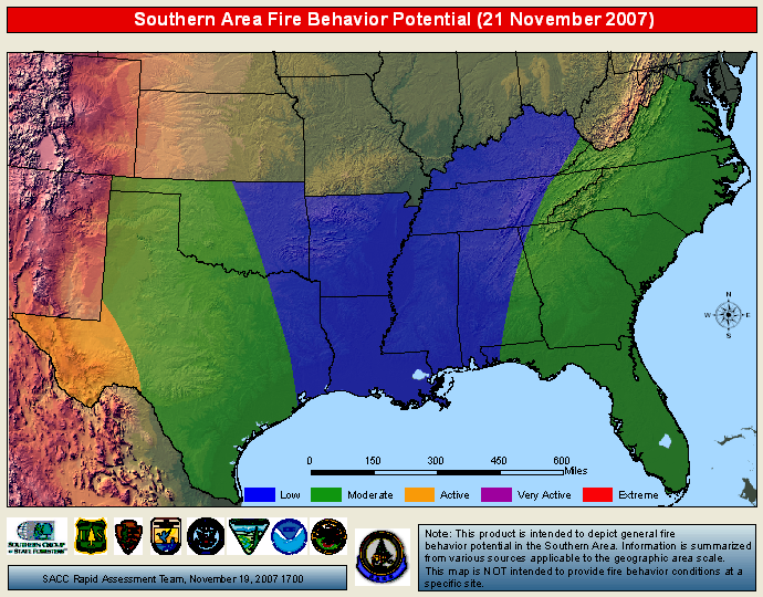
This product depicts very general fire behavior based on weather, fire danger indices, and fuel moisture information. This is intended for general guidance and not intended to replace critical site/fire specific intelligence and fire behavior assessments. Descriptions of fire activity are included below the extended fire behavior outlook.
Adjective Ratings for Fire Behavior:
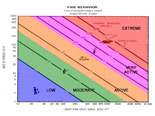
Paper on : Adjective Ratings for Fire Behavior
Energy Release Component Graphs and Drought Maps:
The ERC Interactive Map shows the current and predicted ERCs for the region.
Departure From Average Greenness and Percent of Average Precipitation
(Click maps to enlarge)

Precipitation,
Percent of Normal: Last 15, 30, 60, and 90 Days
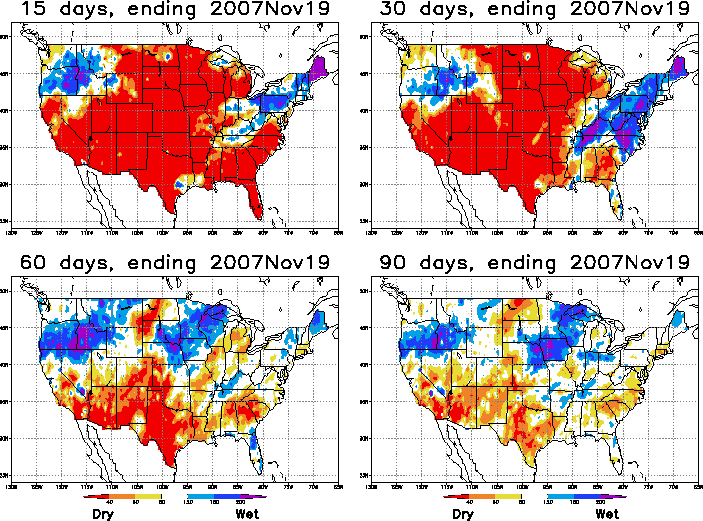
The "Percent of Average Precipitation Map" shows areas of below average precipitation in yellow and red. Areas with above average precipitation are in blue.
Air Operations: Early morning fog may delay flying along coastal areas of South Carolina, the Florida panhandle into southern Georgia and Alabama, and along the coast of Louisiana. Afternoon thunderstorms may occur in Mississippi and Tennessee, producing strong, erratic winds and downdrafts as well as dangerous lightning.
____________________________________________________________________________________________________________________________________
Safety:
Be alert to possible indicators of fire behavior problems:
-
Individual trees or groups of trees beginning to torch.
-
Approaching thunderheads with dark clouds underneath.
-
Presence of dust devils, whirlwinds or fire whirls.
-
Increased spotting.
-
High clouds moving fast in a different direction than the surface wind.
-
A leaning, sheared, or well developed column.
The observation of one indicator does not always mean you will experience extreme fire behavior, but it does key you to be 'heads up' and looking for other indicators.
_____________________________________________________________________________________________________________________________________
**Validation and Feedback:
Please provide us feedback on the accuracy of these forecasts. Your observations about general fuel conditions and observed fire behavior help us validate the accuracy of our forecasts and improve future forecasts.
Remember...initiate all actions based on current and expected fire behavior...Be Safe today
Home | About| Disclaimer | Contact Us

Southern Area
Coordination Center
(678) 320-3000