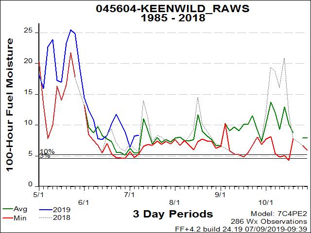
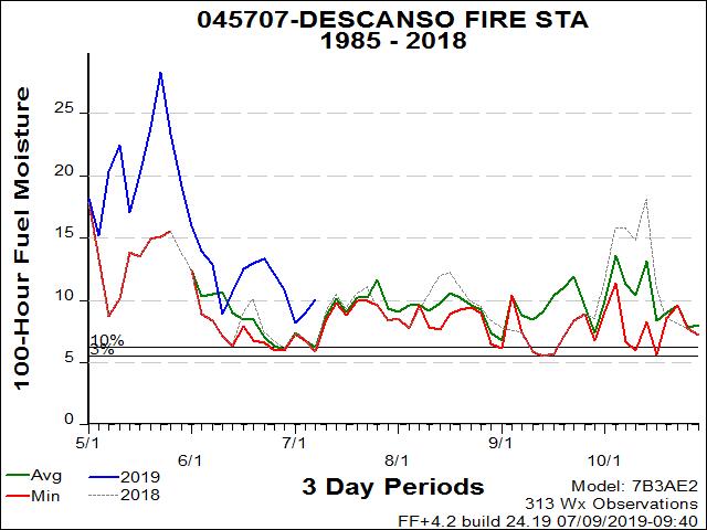
INCIDENT INFORMATION
 
PREDICTIVE SERVICES
  Intelligence
  Weather
  Fuels/Fire Danger
  Outlooks
   
LOGISTICS / DISPATCH
  Aviation
  Crews
   
ADMINISTRATIVE
  California Wildfire Coordination Group
  Policy and Reports
  Incident Business Management
  Safety Management
  Software Applications
  Training
   
RELATED LINKS
 
[graphic] Color Curve
 

YEAR AROUND STATION CHARTS

erc chart

Dead Fuel Moisture

This is the moisture content of dead organic fuels, expressed as a percentage of the oven dry weight of the sample, that is controlled entirely by exposure to environmental conditions.

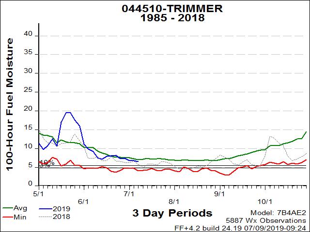
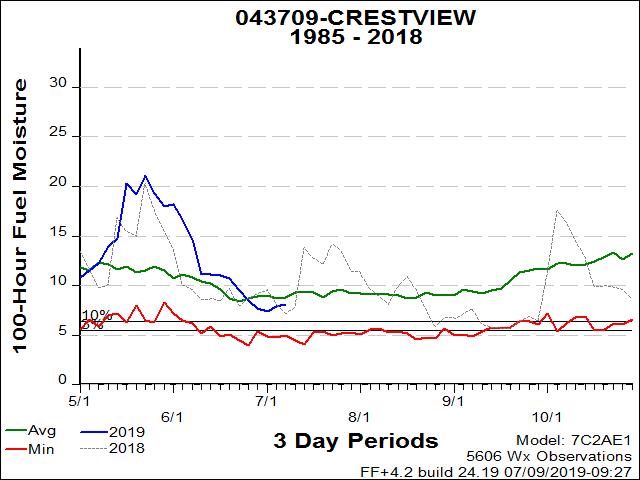
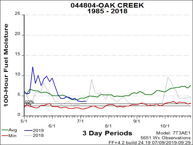
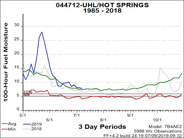
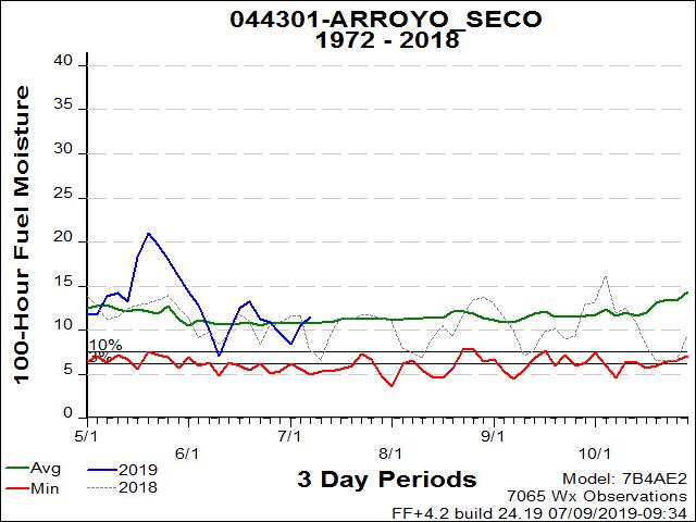
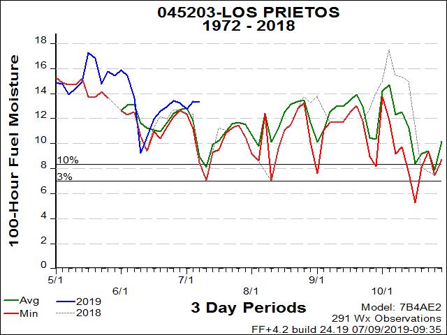
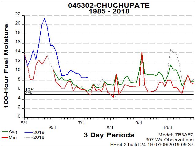
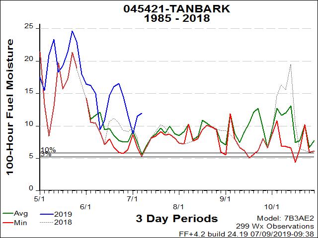
Hundred Hour Dead Fuel Moisture (100hr)

100-Hour dead fuel moisture levels are computed from a 7-day average boundary condition composed of day length, hours of rain, and daily temperature/humidity ranges. Fuel sizes range from 1 to 3 inches in diameter.

Winter conditions of snow covered fuels require that the ERC and fuel moisture graphs be temporarily discontinued. The graphs for this page are generated by FireFamily Plus. Weather station data imported into FireFamily Plus during the months of snow covered fuels does not contain all required information to generate accurate NFDRS outputs. This is due to missing Wet Fuels flag information in the imported FWX data and the FireFamily Plus program not being programmed to utilize the information imported using the FW9 format. Accurate values can be obtained from the Weather Information Management System (WIMS) - if the daily observation represents the snow covered fuels by properly “forcing” the Wet Fuels flag entry.

Most recent update: Monday, 7/8/2019.


YRSC
CHARTS

Mt. Elizabeth

4933 feet

STF

Model: Short Needle (Heavy Dead) (G)


Trimmer

1540 feet

SNF

Model: California Chaparral (B)


Crestview

7600 feet

INF

Model: Pine - Grass Savanna (C)


Oak Creek / Independence

4855 feet

INF

Model: Sagebrush - Grass (T)


Uhl/Hot Springs

3720 feet

SQF

Model: California Chaparral (B)


Arroyo Seco

980 feet

LPF

Model: California Chaparral (B)


Los Prietos

1020 feet

LPF

Model: California Chaparral (B)


Chuchupate

4900 feet

LPF

Model: California Chaparral (B)


Tanbark

2600 feet

ANF

Model: California Chaparral (B)


Keenwild

4920 feet

BDF

Model: Pine-Grass Savanna (C)


Descanso

3480 feet

CNF

Model: California Chaparral (B)

 
[Graphic] - Your First Click to the Federal Government Website

home | about | disclaimer | contact us

Southern California Geographic Area Coordination Center
2524 Mulberry Street
Riverside, CA 92501