INCIDENT INFORMATION
 
PREDICTIVE SERVICES
  Intelligence
  Weather
  Fuels/Fire Danger
  Outlooks
   
LOGISTICS / DISPATCH
  Aviation
  Crews
   
ADMINISTRATIVE
  California Wildfire Coordination Group
  Policy and Reports
  Incident Business Management
  Safety Management
  Software Applications
  Training
   
RELATED LINKS
 
[graphic] Color Curve
 

PSA SIG GROUP CHARTS

erc chart

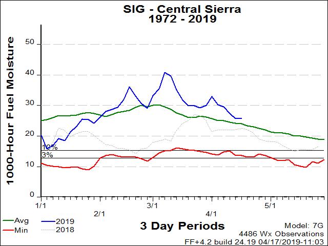
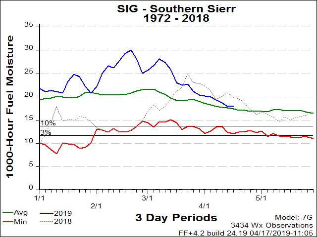
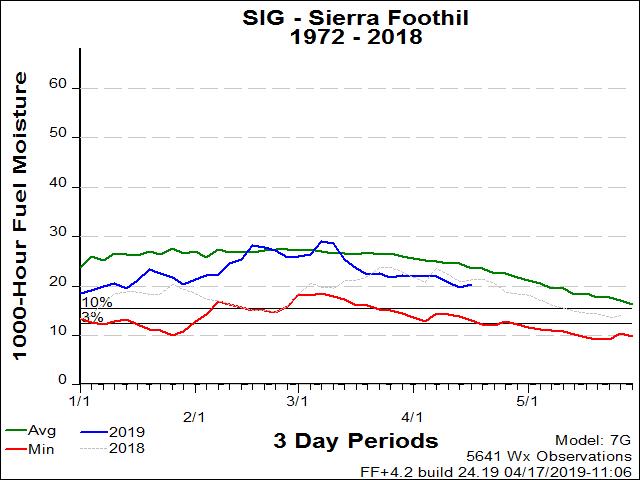
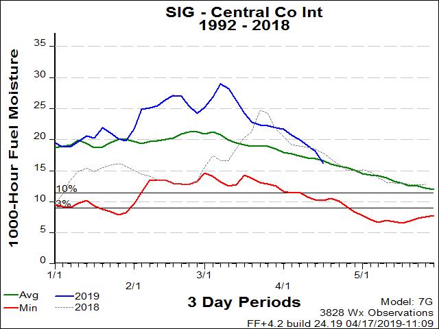
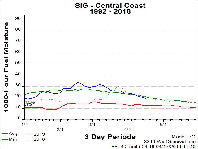
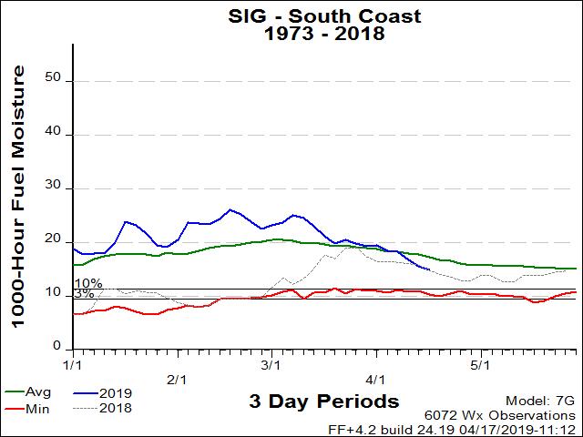
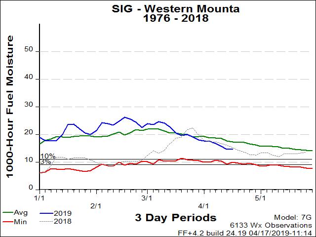
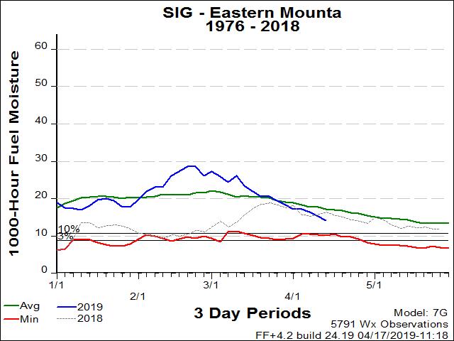
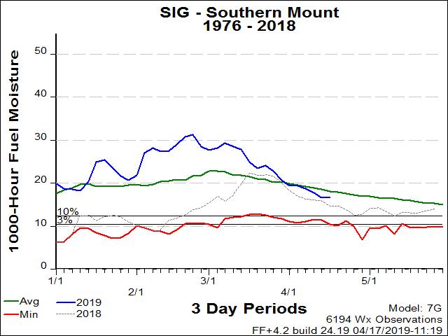
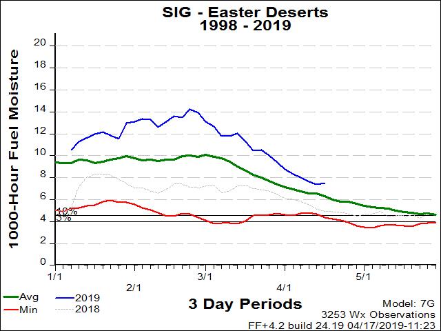
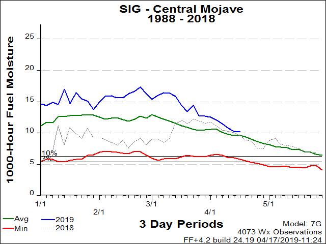
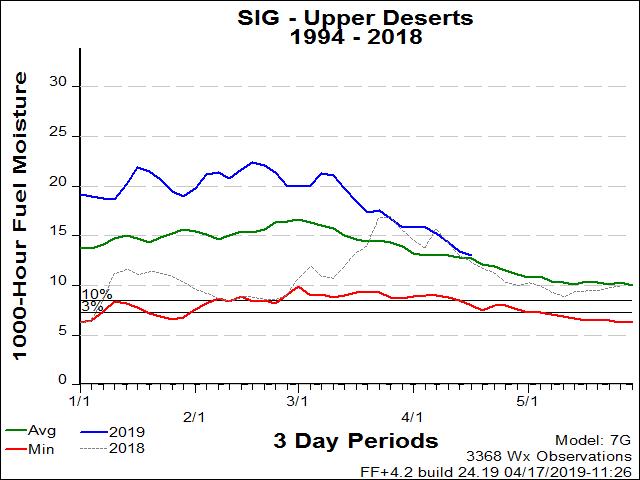
The Thousand Hour Dead Fuel Moisture Component is an NFDRS (National Fire Danger Rating System) index.

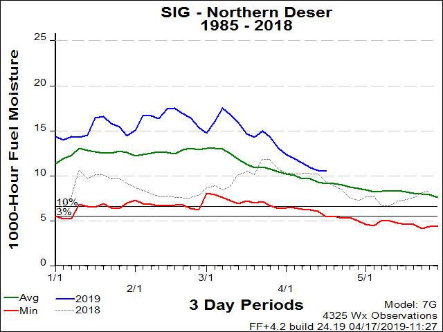
This is the moisture content of dead organic fuels, expressed as a percentage of the oven dry weight of the sample, that is controlled entirely by exposure to environmental conditions.

1000-Hour dead fuel moisture levels are computed from a 7-day average boundary condition composed of day length, hours of rain, and daily temperature/humidity ranges. Fuel sizes range from 3 to 6 inches in diameter.

Charts are from selected RAWS in each PSA and are arranged generally from the northern part of the Geographic Area to the southern part. The weather stations used represent the best fire danger conditions for that PSA. Most stations contain at least twenty years of historical weather data. Data collected prior to 1976 is not used in these analyses due to an issue with the relative humidity measurements before that time.

Winter conditions of snow covered fuels require that the ERC and fuel moisture graphs be temporarily discontinued. The graphs for this page are generated by FireFamily Plus. Weather station data imported into FireFamily Plus during the months of snow covered fuels does not contain all required information to generate accurate NFDRS outputs. This is due to missing Wet Fuels flag information in the imported FWX data and the FireFamily Plus program not being programmed to utilize the information imported using the FW9 format. Accurate values can be obtained from the Weather Information Management System (WIMS) - if the daily observation represents the snow covered fuels by properly “forcing” the Wet Fuels flag entry.


Most recent update: Monday, 9/5/2016.

   
YRSC
CHARTS

Eastern Sierra PSA SIG Group

Stations Used:

Crestview
Rock Creek

Model: Short Needle (Heavy Dead) (G)

Central Sierra PSA SIG Group

Stations Used:

Beaver
Mt. Elizabeth
Shaver

Model: Short Needle (Heavy Dead) (G)

Southern Sierra PSA SIG Group

Stations Used:

Black Rock
Cedar Grove
Johnsondale
Park Ridge
Sugarloaf

Model: Short Needle (Heavy Dead) (G)

Sierra Foothills PSA SIG Group

Stations Used:

Catheys Vly
Esperanza
Fancher Ck
Green Spr
Mariposa
Trimmer
Oak Opening
North Fork

Model: Short Needle (Heavy Dead) (G)

Central Valley PSA SIG Group

Stations Used:

Kettleman Hills
Fancher Ck

Model: Short Needle (Heavy Dead) (G)

Central Coast Interior PSA SIG Group

Stations Used:

Parkfield
Carrizo
Hernandez
La Panza
Carrizo

Model: Short Needle (Heavy Dead) (G)

Central Coast PSA SIG Group

Stations Used:

Los Prietos
Las Tablas
Arroyo Seco
Arroyo Grande

Model: Short Needle (Heavy Dead) (G)

South Coast PSA SIG Group

Stations Used:

Case Springs
Cheeseboro
Claremont
Malibu Hills
El Cariso
Saugus
Valley Center
Devore

Model: Short Needle (Heavy Dead) (G)

Western Mountains PSA SIG Group

Stations Used:

Chilao
Chuchupate
Ozena
Mill Creek (ANF)
Rose Valley
Warm Springs
Tanbark
Mormom Rock

Model: Short Needle (Heavy Dead) (G)

Eastern Mountains PSA SIG Group

Stations Used:

Converse
Big Pine Flat
Fawnskin

Model: Short Needle (Heavy Dead) (G)

Southern Mountains PSA SIG Group

Stations Used:

Alpine
Descanso
Julian
Keenwild
Mt. Laguna
Oak Grove

Model: Short Needle (Heavy Dead) (G)

Lower Deserts PSA SIG Group

Stations Used:

Squaw Lake

Model: Short Needle (Heavy Dead) (G)

Eastern Deserts PSA SIG Group

Stations Used:

Squaw Lake
Rice Valley

Model: Short Needle (Heavy Dead) (G)

Central Mojave PSA SIG Group

Stations Used:

Horse Thief Spring
Yucca Valley
Mojave River Sink

Model: Short Needle (Heavy Dead) (G)

Upper Deserts PSA SIG Group

Stations Used:

Acton
Poppy Park
Saddleback Butte

Model: Short Needle (Heavy Dead) (G)

Northern Deserts PSA SIG Group

Stations Used:

Benton
Panamint
Oak creek
Horse Thief Spring

Model: Short Needle (Heavy Dead) (G)

[Graphic] - Your First Click to the Federal Government Website

home | about | disclaimer | contact us

Southern California Geographic Area Coordination Center
2524 Mulberry Street
Riverside, CA 92501