Maps, Imagery, and Geospatial Services
Online Maps
NWCC GIS maintains and publishes several ArcGIS online webmaps which are updated daily during fire season or as activity levels warrant.
Several of our web maps are bundled in this "Current Situation" map gallery:
GISS Toolbox
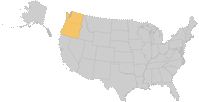
Northwest GIS Data
-
Interagency Fire Data Disks
Each R6 National Forest Supervisor's Office and each Oregon/Washington BLM District office keeps a borrow-able data disk on-site. Here at NWCC we maintain and make available several interagency data disks for incoming teams as well and maintain a Fire Data Disk AGOL group. To learn more, about these disks, securing access for downloading most of the data directly, or access to the AGOL group, contact NWCC GIS at ornwc_gis@firenet.gov.
NWCC - GIS Coordinator
Phone 503-808-2741
ornwc_gis@firenet.gov
https://gacc.nifc.gov/nwcc
National | NWCC Home | About Us | Site Disclaimer | Contact Us


Questions or suggestions regarding website content or design should be directed to blm_or_nwcc@blm.gov. (Please copy the email address into a composed email to send to us)
This is a US Government Computer System; before continuing, please read this Disclaimer, as well as our Privacy Policy.